This website is part of The New York Public Library's Online Exhibition Archive. For current classes, programs, and exhibitions, please visit nypl.org.
American Shores Maps of the Middle Atlantic Region to 1850 The New York Public Library
Map Collection
Overview Basics of Maps Maps Through History Geographical Areas

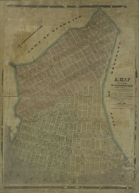
Williamsburg, Brooklyn


Williamsburg, 1845.
catalog record

Every block and lot is shown for Williamsburg as of 1845, for the purpose of tax assessment. North is to the lower left of this map, and the East River is at the bottom margin, where the mapmaker has drawn in plans for further landfill and expansion of these lots into the water.

Williamsburg, just north of Wallabout Bay, is an area of factories and a significant commercial waterfront. It was surveyed and developed shortly after the Revolution, and grew rapidly after 1792 when a horse ferry was established from Manhattan. In 1849 Williamsburg became a city, and in 1854 it was annexed to Brooklyn.


Privacy Policy | Rules and Regulations | Using the Internet | Website Terms and Conditions | © The New York Public Library