|
 |
 |
|
|||
 |
 |
|
|
|||
|
|
||||||
| |
|
|
|
|
||
|
|
|
|
|
|
|
|
|
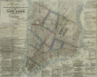
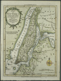
| New York City
New York City and the surrounding countryside, including New Jersey, Connecticut, and Long Island, were first settled by various Native American groups, from the Lenni Lenape in New Jersey to the Shinnecock on eastern Long Island. The Dutch explored the area via Henry Hudson, who, while English, worked for the Dutch. Hudson produced no maps of the area, but his pilot, Robert Juet’s journal, published in 1625, provides evocative descriptive information about the plant and animal life of the region before European settlement changed it all forever. New Amsterdam was the Dutch settlement at the south end of Manhattan, below what is now Wall Street. When the city was captured by the English, it was renamed New York. The first capital of the United States under the
Constitution, in 1789-90, and the new nation's largest
To read more about the mapping of New York City, please consult: Manhattan in maps, 1527-1995, Cohen, Paul E. and Robert T. Augustyn. New York : Rizzoli International Publications, 1997. catalog record "The Montresor-Ratzer-Sauthier series
of maps of New York City.", Cumming, W. P. "Manhattan on Paper: The mapping of
property and environment in Manhattan since the 1600s, with a check
list of property maps and atlases.", Hudson, Alice C.
In Biblion, the bulletin of the New York Public Library, vol. I,
number 2, Spring 1993, pp. 39-70. The iconography of Manhattan Island, 1498-1909, compiled from original sources and illustrated by photo-intaglio reproductions of important maps, plans, views and documents in public and private map collections., Stokes, I. N. Phelps. New York: Robert H. Dodd, 1915-1928. 6v. catalog record
|
||||||||