|
 |
 |
|
|||
 |
 |
|
|
|||
|
|
||||||
| |
|
|
|
|
||
|
|
|
|
|
|
|
|
|
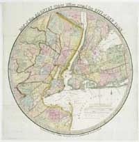
New York City neighborhoods
Both New Amsterdam and New York City, early on, were limited in area to lower Manhattan. A variety of other villages sprung up in Long Island and Westchester, portions of which are now the boroughs of Brooklyn, Queens, and the Bronx. These separate independent villages grew and developed, and were subsequently annexed to Manhattan, the Bronx, Brooklyn, and Queens, and all these locales became part of greater New York in 1898.
To read more about these towns and villages please consult the following: French, J. H. Gazetteer of the State of
New York. Syracuse: R. Pearsall Smith, 1860. |
||