|
About 200 miles long, and ranging from 3 to over
30 miles wide at different points, the Chesapeake Bay is a tremendous,
sheltered waterway. It was among the earliest North American areas
settled and developed by Europeans, and was prized for its rich
oyster, crab and tobacco harvests. The many rivers that flow into
the Bay, prominently the Susquehanna, the Potomac, and the James,
provided early access to the interior of the continent. This deep
arm of the Atlantic was the interior’s link to oceanic trade
with Europe and the West Indies.
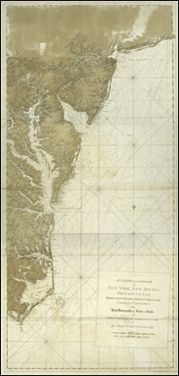
The Atlantic cuts deeply into the North American continent via Chesapeake
Bay. This is well illustrated in a startlingly beautiful chart from
the Atlantic Neptune, a collection of English nautical
charts in an atlas format. Bounded on one side by the Delmarva Peninsula,
the protected lands and waters of the bay formed a natural settlement
place for the English colonists who arrived in 1606.
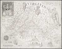 |
Virginia, 1606.
catalog
record
This is actually a 19th-century facsimile
of Smith's 1606 map, created by some bibliophiles in Virginia
in 1819. John Smith was among the first to map the Chesapeake
region, and to give credit to Native Americans for information
about the frontier lands away from the Atlantic shores. The
formée crosses on his map of Virginia reveal the boundary
beyond which the information shown was from Native American
sources. The earliest maps of the Middle Atlantic region often
reflect knowledge gained from Native Americans, and sometimes
display the only information we have for the original settlers
along the Atlantic shore. The Smith map has been used extensively
to guide Virginia archaeological research. |
To read more about the mapping of the Chesapeake
region, see:
Washington College presents On the map :
an exhibit and catalogue
of maps relating to Maryland and the Chesapeake Bay honoring George
Washington at the beginning of the third century of Washington College
at Chestertown, Maryland, February 21-March 6,1983 / by Russell
Morrison ... [et al.].
Chestertown, Md. : The College, 1983.
catalog
record
|