 |
A map of the canals & rail
roads of Pennsylvania and New Jersey,
and the adjoining states, 1846.
catalog
record
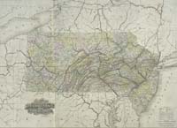
This political map of Pennsylvania
and New Jersey clearly identifies the counties of each state,
using color to differentiate them. The growing railroad network
is shown with a thin orange-red line, especially visible at
the bottom on the Maryland portion of this map. As early as
this, 1846, we can see a direct link between Washington, D.C.,
and New York City. A previous 19th-century owner of this map,
probably a New Yorker, has handwritten faintly in pencil the
names of the various New York State counties.
|
Pennsylvania was settled first by Swedes in 1643,
along the Delaware River. In 1681-82, William Penn was granted Pennsylvania
and Delaware by the English. Religious freedom, which Penn allowed
in the colony attracted thousands of settlers. Philadelphia, on
the Delaware River, was the major Pennsylvania urban area along
the Middle Atlantic coastal region.
During the Revolution, Philadelphia was occupied
by the British and there were important battles at Germantown and
at Brandywine, where General Washington was defeated. His famous
winter encampment was at Valley Forge.
Strong links between the two urban centers
of New York City and Philadelphia, across New Jersey, were established
by road, canal, and railroad connections which brought the oil and
mineral wealth of Pennsylvania to the coast. Along with the Erie
Canal, these links to the interior brought natural resources to
the East Coast, enriching New York City.
|


