|
 |
 |
|
|||
 |
 |
|
|
|||
|
|
||||||
| |
|
|
|
|
||
|
|
|
|
|
|
|
|
|
|
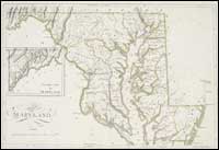
Maryland
Named for Queen Henrietta Maria of England, consort of Charles I, Maryland was colonized by English Roman Catholics in 1634. Baltimore, its largest city, was established in 1729. Annapolis is the State capital. The original charter for Maryland, granted by Charles I of England, defined the region generally between Latitude 40 degrees North and the Potomac River. Boundary disagreements with Virginia remained problematic until the 20th century. The Mason-Dixon line of 1767 settled the dispute with Pennsylvania. The Chesapeake Bay almost splits the state, and provides its major marine food sources: oysters, softshelled crab, and terrapin. In the western part of the state, iron, building stone, and coal provided important 19th-century mining activities. The Baltimore and Ohio Railroad, the first of the major lines, was begun in 1828. By 1830 there were 15 miles of track; by 1849, 259 miles. The early canals and railroads and national highways in the state brought great wealth to Maryland.
For more on the mapping of Maryland, visit the Maryland Historical Society. To read more about the mapping of Maryland, consult these books: The Mapping of Maryland, 1590-1914 : an overview.
Baltimore : Museum and Library of Maryland History, Maryland Historical
Society, 1982. catalog
record |
||