 |
New Jersey, ca. 1702.
catalog
record
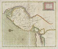
This is just one plate from John
Thornton’s massive atlas of maritime charts covering
the entire nautical world. On this copper-engraved early English
nautical chart includes soundings in New York harbor, Delaware
Bay, and off shore. The diagonal lines are early colonial
boundaries. The beautiful hand-colored outline and wash coloring
is original.
|
North and South New Jersey (or East and West Jersey in colonial
times) have always differed in some respect—geographically,
politically. The northern areas were settled by the Dutch, and had
a commercial focus strongly oriented toward the New York City market.
The southern part of the state was settled by Swedes along the Delaware,
and was a more rural farm-based economy linked to Philadelphia markets.
The Dutch eventually took over the Swedish colonies, and those were
subsequently taken by the English. The royal province of New Jersey
was established by the English in 1702. During the American Revolution,
New Jersey was a crossroads of conflict with action at Trenton,
Princeton, and Monmouth. At one point, Morristown was a headquarters
for General Washington.
|


