|
Established in 1682 as a Quaker colony by William
Penn, the city of Philadelphia site was the previous home of Lenni-Lenape
Indians and even a Swedish colony. Philadelphia was the American
capital during the American Revolution, and again from 1790 until
1800, at which point the national capital was moved to a newly built
Washington City, in the District of Columbia.
Philadelphia is a planned, gridded city, with
the population filling the grid from east to west, from the Delaware
River shore to the Schuykill River.
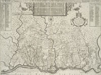 |
Philadelphia, Pa., 1687.
catalog
record
This map of Philadelphia was created
by Thomas Holme within five years of the founding of the colony,
so it is among the earliest representations of that city. At
the top center of the map is an enlarged drawing of the early
gridded plan for Philadelphia. North is to the left. At bottom
center of the map we can see the proposed Philadelphia grid
set in the context of southeastern Pennsylvania. Many landowners
names are recorded on the map, making this an invaluable record
of the early settling of Pennsylvania. |
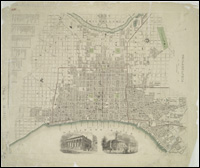 |
Philadelphia, 1840.
catalog
record
The Society
for the Diffusion of Useful Knowledge was made up of a group
of learned gentlemen who wished to spread good geographical
information across the land. They created a series of maps and
atlases following the same design scheme seen on this Philadelphia
map. Gray, black, and white maps were highlighted in turquoise
for water, and in red for political boundaries, such as wards. |
For more information on the early mapping of Philadelphia,
see the U.S.
Library of Congress American Memory website:
To read more about the early mapping of Philadelphia, Pa. consult:
Philadelphia mapmakers Moak, Jefferson M. , c1976 catalog
record
|


