 |
 |
 |
|
|||
 |
 |
|
|
|||
|
|
||||||
| |
|
|
|
|
||
|
|
|
|
|
|
|
|
|
|
Overview
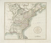
The Mid-Atlantic region of North America – stretching from New York south to Virginia – was a pivotal area in the early development of the American colonies and the United States. This website looks at this region and its history through maps created up to 1850. The cartographic record created on paper by the early mapmakers preserves, places and events in the physical and historical context of the time in which the maps were made. Much of that context no longer exists on land, as development and growth have ridden roughshod over the past. The maps on this site cover the early modern period ending in 1850, just as so-called internal improvements (canals, highways, and railroads) began to cross the young nation and change the landscape. These early maps provide contemporary documentation of particular times and places and present a compelling way to study history today. The digitized maps and atlases included in American Shores are drawn from the extensive holdings of the Map Division of the Humanities and Social Sciences Library. In particular, the maps by English mapmakers from the Lawrence H. Slaughter Collection form the core of this site. American Shores allows you to explore these digitized maps in three ways. This website highlights and explains a few of the hundreds of maps that have been digitized and offers suggestions for using them in the study of historical topics or geographic areas. Many of the maps can be viewed in detail by using the MrSid viewer. The entire collection of digitized maps also can be searched using a keyword search, via the digital database. The development of American Shores Maps
of the Middle Atlantic Region to 1850 has been supported by
a grant from the National Endowment
for the Humanities, an independent
federal agency. |
||
