Trade, the food of empire, requires the creation
of maps. How else to keep track, literally, of ships’ paths
from Europe to Africa to the West Indies and America laden with goods,
slaves, settlers, criminals, indentured servants, etc. All the workers
helped turn the wheel of trade, which allowed the production of maps,
purchased by a growing merchant class and newly literate public. The
relationship of the Middle Atlantic region to its international trading
partners can be seen only on these maps of worldwide coverage.
 |
World, 1790.
catalog
record
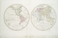
The double-hemisphere design became
popular for world maps after the full extent of the Americas
was known. The presentation of the earth's geographic spaces
as equal units had been a popular classical motif, and its use
continued well into the 18th century. It implies the roundness
of the earth, which the rectangular Mercator projection on the
map does not. This particular 1790 map emphasizes exploration
and trade. Captain Cook’s and other explorers' oceanic
routes are shown, and for trading purposes, all the important
ports are named. Notice that Chesapeake Bay is written well
out into the Atlantic, and Philadelphia and Annapolis are named
also. |
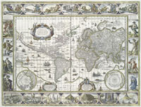 |
World, 1635.
catalog
record
This is a very early Mercator projection
map of the world. The two edges, right and left, meet to form
a whole cylindrical earth. The map is encyclopedic in the information
provided: flying fish and sailing ships dot the ocean; small
azimuthal polar maps appear in the corners; the grid of latitude
and longitude covers the map; one label and two dedicatory cartouches
decorate the map; full and partial compass roses emphasize the
northerly orientation; and 14 views of cities and 8 cartes à
figure representing the four seasons and the four classical
elements (earth, air, wind, fire) decorate the margins. To convert
all the visual information into words would take pages and pages
of text. |
|


