 |
Albany.
1828.
catalog
record
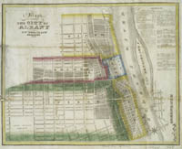
The bright
colors on this map identify the wards, or political divisions,
of the city in 1828. The Hudson River is to the right, and a
star design provides compass directions. The text in the upper
right corner lists government offices, property owners, churches,
banks, libraries, and markets. The signature on the map appears
to be that of Jno. S. Walsh, and is backwards, as it has bled
through from the back of the map. |
The state capital, Albany was once known as Beaver
Wyck, reflective of the 17th century Dutch fur trade headquartered
there. It was renamed in 1664 for James, Duke of York and Albany,
who later became King James II of England.
Albany's location at the termination of the canals and railroads
made it a center of trade and transshipment. In the 1840s, 18 stage
lines and several railroads brought in passengers and goods daily.
In the same era, some 27 steamboats and 51 barges regularly transported
goods from Albany to New York City.
 |
Albany.
1818.
catalog
record
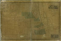
Covered by a glaze when produced in
1818, the glaze has since darkened, making this map difficult
to read. However, on close inspection the wards, street names,
and local landmarks can be seen. At the upper left corner
is the Albany city seal and the 1818 state capitol building. |
To read more about places in New York State, see:
John Disturnell. A gazetteer of the State
of New-York...Albany, 1843.
catalog
record
|


