|
 |
 |
|
|||
 |
 |
|
|
|||
|
|
||||||
| |
|
|
|
|
||
|
|
|
|
|
|
|
|
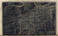
| Utica
Utica, on the Mohawk River near the site of the
old British Fort Schuyler in Oneida County, is some 90 miles west-northwest
of Albany. It was incorporated in 1817, and is located on the great
trading road from Albany west to the Great Lakes. The Erie Canal
connected Utica to the Middle Atlantic markets. |
||