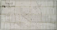
This website is part of The New York Public Library's Online Exhibition Archive. For current classes, programs, and exhibitions, please visit nypl.org.
American Shores Maps of the Middle Atlantic Region to 1850 The New York Public Library
Map Collection
Overview Basics of Maps Maps Through History Geographical Areas

Troy

Troy, 1845.
catalog record

On this map of 1845 Troy, note that North is to the left! The Hudson River flows south toward the right. Numerous factories can be seen along the river, according to the legend at the upper right corner, and someone has drawn, in red, the path for a future electric railway line.

Located at the head of steam navigation on the Hudson River, Troy is near the terminus of both the Erie and the Champlain canals, and links to several rail lines. Daily steamers and barges ply their way from here to New York City, connecting the interior to the Atlantic coast.


Privacy Policy | Rules and Regulations | Using the Internet | Website Terms and Conditions | © The New York Public Library