|
 |
 |
|
|||
 |
 |
|
|
|||
|
|
||||||
| |
|
|
|
|
||
|
|
|
|
|
|
|
|
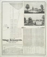
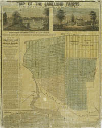
| Islip Islip, first organized in 1710, is on the south shore of Long Island on Great South Bay in Suffolk County. In the 1820s, “hunting, fishing and fowling” employed many locals. By the 1840s, some 1,900 people lived in the area. The two maps below promote new real estate developments in the town of Islip, specifically near the Long Island Railroad. Both maps stress easy access from New York City to these suburban homesteads via the rails.
|
||||