|
Made up of four counties, Kings, Queens, Nassau,and
Suffolk, Long Island was settled by the Dutch and English in the
17th century, displacing many local Native Americans. A remnant
still live in Suffolk County, especially near the Shinnecock reservation.
Oriented east-west, Long Island is characterized
by the terminal glacial moraines which form its highest elevations,
arranged rather like a spine lengthwise along the center of the
island. Highways and railroads follow this strip of high ground,
which was a determining factor in how the towns and villages spread
out.
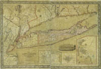 |
Long Island, 1844.
catalog
record
This large wall map of Long Island is very detailed, showing
roads and railroads and even the location of individual houses
in the more rural areas south and east of Brooklyn. The map
also includes the same detail for a good portion of Rockland
and Westchester counties, Bergen County, and southwestern Connecticut. |
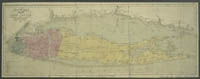 |
Long Island, 1843.
catalog
record
This green, pink, and yellow map of Long Island shows the counties
before Nassau was split off from Queens in 1898. Early on, county
size was often unrelated to population. Suffolk was a huge county
in relation to Kings and Queens, but it had a very small population.
The very beginning of the Long Island Rail Road can be seen
connecting Brooklyn and Millville, Suffolk County.
|
|


