|
 |
 |
|
|||
 |
 |
|
|
|||
|
|
||||||
| |
|
|
|
|
||
|
|
|
|
|
|
|
|
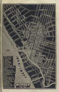
| Buffalo
Buffalo, located at the eastern terminus of the Great Lakes and the westernmost point of the Erie Canal, linked Albany and the Middle Atlantic states with the great western grain and lumber sources and markets beyond the Great Lakes’ shores. The lakes reached 1,300 miles further into the heartland, making the Erie Canal/Great Lakes an economic engine for the benefit of the Middle Atlantic states. In 1840 more than 4,000 vessels cleared customs at Buffalo, and 178,000 tons of goods were shipped on the Erie Canal to eastern markets along the Middle Atlantic coast.
|
||