 |
Dutchess County,
1850.
catalog
record
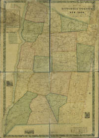
This large county map of Dutchess County
has suffered some water damage, sadly on the Poughkeepsie
inset, at the upper left. However, a close view of that inset
reveals family names on various blocks, and shaded areas reflecting
built-up areas. Notice the Vassar brewery and the ropewalk
(a factory for winding rope to manufacture ships' rigging).
Located on the Hudson River, Poughkeepsie housed two whaling
companies, and many river barges and oceangoing sloops. |
Poughkeepsie, in Dutchess County, on the eastern
shore of the Hudson River, is 70 miles north of New York City. It
was settled by the Dutch in 1735. By 1824 ten sloops or packet ships
a week were delivering commercial and agricultural goods to New
York City from Poughkeepsie. In 1788 the state convention met here
and successfully ratified the new federal constitution of the United
States, despite early majority opposition to the constitution by
the New York delegates.
|


