|
Unlike a town that just grew up naturally and
organically alongside a riverbank, Washington was a totally planned
city. Congress declared that a permanent capital city must be established
and built by 1800, and it was. Accustomed to the comforts of an
established city, not a lot of Congressional legislators were eager
to leave cushy Philadelphia for the unpaved streets of Washington
in the District of Columbia, carved out of muddy farmland along
the Potomac.
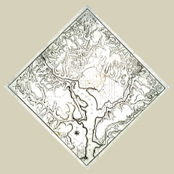 |
Territory of Columbia, 1794.
catalog
record
The streets of Washington are much like
the angled pathways of the gardens of Versailles, which may
have influenced Pierre L'Enfant, the city's designer. A French
soldier who volunteered for the Americans in the Revolution,
he was an acquaintance of George Washington. With his strong
personality, L'Enfant clashed with Congress, which fired him
before the layout of the new national capital was completed.
Andrew Ellicott was called on to complete the survey of the
city, and it is his name we see on many of the early maps
of Washington, not L'Enfant’s. |
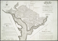 |
Washington,
1792.
catalog
record
A more developed plan of just the City
of Washington, within the District, assigns each block a number,
most likely to facilitate the location and sale of lots in
the new city. Georgetown, to the west of the new capital,
is a historically Black community which predated the establishment
of Washington, and was incorporated into that city in 1895.
Notice that the mapmaker has made Washington the line of zero
longitude. All measurements in the new nation would start
from here, not Greenwich, England--surely a cartographic statement
of independence! |
If you are interested in the mapping of Washington,
D.C., check the American
Memory website of the United States Library of Congress.
To read more about the mapping of Washington, D.C., consult the
following books:
City of Magnificent Distances, the Nation's
Capital (1991-1992 : Library of Congress)
City of magnificent distances, the nation's capital : a Library
of Congress exhibit, Madison Gallery, October 17,1991-March 15,1992.
[Washington] : Library of Congress, [1991]
catalog
record
Ristow, Walter William, 1908- comp.
A la carte; selected papers on maps and atlases. Washington,
Library of Congress [for sale by the Supt. of Docs., U.S. Govt.
Print. Off.] 1972.
catalog
record
|


