|
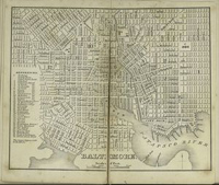
Baltimore was established as a city in 1729, becoming
the most important port in the United States until the Erie Canal
steered commerce toward New York City.
Situated below the Mason-Dixon line, Baltimore
has the flavor of the urban north and southern warmth. It is an
important shipbuilding center, where many 19th-century clipper ships
were built. During the American Revolution, the Continental Congress
met in Baltimore, after English soldiers took the national capital,
Philadelphia. Fort McHenry, just southeast of the city, was built
around 1790-1800 to defend the harbor. It was under siege during
1814 by the British, and that battle inspired Francis Scott Key
to write “The Star-Spangled Banner.”
For more information on
the mapping of Baltimore, see the following websites:
Maryland
State Archives Map Collections
Maryland
Historical Trust's Library holdings
|