|
Brooklyn was organized as a township in 1667, with the smaller village
of Brooklyn incorporated as a city in 1816. Both town and city were
incorporated into a city in 1834. When Williamsburg was annexed
to Brooklyn in 1855, Brooklyn became the third largest city in the
United States.
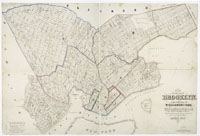 |
Brooklyn, 1846.
catalog
record
Similar to the 1849 map nearby, this map emphasizes the wards
for the city of Brooklyn. It also identifies farm owners. North
is toward the bottom of the map, so it takes a bit of reorienting
to get the perspective right.
|
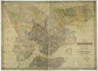 |
Brooklyn, 1849.
catalog
record
Wards are delineated by red lines, and older farms are identified
by solid-color wash and italic names. The wetlands around the
Gowanus creek are clearly shown. Governors Island can be seen
before the landfill that doubled its size, and Castle Garden
is still out in the harbor, before landfill surrounded it, embedding
it in Manhattan Island. |
|


