This website is part of The New York Public Library's Online Exhibition Archive. For current classes, programs, and exhibitions, please visit nypl.org.
American Shores Maps of the Middle Atlantic Region to 1850 The New York Public Library
Map Collection
Overview Basics of Maps Maps Through History Geographical Areas

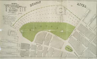
Battery Park, Manhattan

Battery Park, 1849
catalog record

The original Battery was a line of cannon from the foot of Greenwich Street to the intersection of Whitehall and Water streets. The land beyond this boundary was underwater until around 1800, when landfill extended the shore outward.


Privacy Policy | Rules and Regulations | Using the Internet | Website Terms and Conditions | © The New York Public Library