|
 |
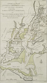
Staten Island, 1776.
catalog
record
Published during the American Revolution to inform the British
public about the theater of war in the New York area, this map
emphasizes Staten Island, perhaps because in 1776, British General
Howe met in conference with the American Patriots at the “Conference
House” on Staten Island, to negotiate a settlement after
the British victory in the Battle of Long Island. The Americans
refused to settle without gaining independence, and the Revolution
was on. Note also the “North or Hudsons River,”
the shaded area showing the urbanized area of lower Manhattan,
and the Sandy Hook lighthouse, built in 1763 and the oldest
lighthouse still operating in the United States today. |
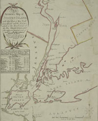
Richmond County was established in 1683, and included
Staten Island, Shooters Island, and islands in Staten Island Sound.
Oystering was a major occupation along its shores, and a number
of factories manufactured cloth goods, candles, white lead, and
ivory black. Breweries were plentiful, and made this a Sabbath day
getaway for German workers in the city, who frequented the saloons
and restaurants nearby. Today Richmond County and the borough of
Staten Island are coextensive.
|