|
 |
 |
|
|||
 |
 |
|
|
|||
|
|
||||||
| |
|
|
|
|
||
|
|
|
|
|
|
|
|
| Collect Pond, Manhattan
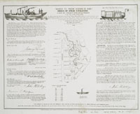
Located just north of the present City Hall, the natural spring-fed Collect Pond was the main source of fresh water for New York City until the Croton Aqueduct system was opened. The African American burial ground was adjacent to Collect Pond, along with the city armory and a tannery. Gunpowder, animal slaughter, and burial sites must not have made for a pleasant scene. A canal was built to drain the now fetid pond, and that canal later was paved over to form Canal Street. On early maps of the city, such as the Montresor map of 1767, one can see the low marshy ground, which demanded drainage. John Fitch is said to have tested his steam
engine in Collect Pond in 1793, and there are numerous commemorative
maps attesting to his experiments, which predated the work of Robert
Fulton.
|
||