Flushing was at first a patent granted in 1645
by the Dutch Governor Keift to English immigrants, primarily Quakers.
The Meeting House, built in 1698, still stands. The Bowne house, built
in 1661, was the first, and secret, meeting place of the Quakers.
Flushing was recognized as a town by New York State in 1788. Gardening
and nurseries formed the early economy. The town also had a poor house.
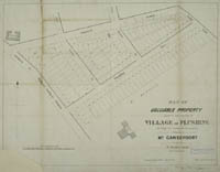 |
Map of Valuable property,
Flushing, 1852.
catalog
record
The Gansevoort property was sold to a Mr. D. S. Williams according
to an 1852 map of the area. The St. Thomas Hall later became
St. Joseph’s Academy for young girls; and Sandford Hall
was bought by Dr. John Macdonald, who turned this elegant private
home into a celebrated private insane asylum. This property
is now located at the southeast corner of the intersection of
Sanford Avenue and Kissena Boulevard. |
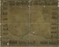 |
Flushing, 1841.
catalog
record
Covered with a glaze at some point, and framed (nail holes can
be see at the bottom margin), this map is detailed enough to
show individual property owners’ names. North is to the
left, not at the top of the map. St. Thomas Hall is described
at the bottom left, and appears at the top right on this map.
A view of St. Thomas Hall is at the bottom margin.
Many important buildings appear decoratively illustrated at
the margins of the map. |
|


