Part I: Founding Cities
Washington, D.C.
Once the American Revolution was won, there were many years of debate about
where the capital city of the United States should be located. It was finally
agreed in 1790 that Maryland and Virginia would cede portions of their territory
on the Potomac River as a site for a national capital. Adjacent to the successful
towns of Georgetown and Alexandria, founded some forty years earlier, the
site afforded the assurance of commercial viability along with the space for
an idealized city worthy of the new republic’s aspirations.
The city’s plan was designed in 1791 by Major Pierre-Charles L’Enfant,
a French engineer and artist who fought in the American Revolution. According
to Thomas Jefferson’s instructions, L’Enfant was to work with
the surveyor Andrew Ellicott to determine the best positions for the “federal
town and its buildings.” L’Enfant, whose sensibility was informed
by a childhood spent in Paris and Versailles, where his father worked
on the
Ministry of War building, came up with a visionary plan (shown in Ellicott’s
1792 etching, number 15). Construction began in 1793, the government
moved officially in December 1800, and despite complaints about its remoteness
and “wilderness” aspects, by about 1850, when the Weber and Sachse
views were published, Washington was accepted both symbolically and practically
as the seat of government of the rapidly developing United States.
14
Georgetown and Federal City, or City of Washington
T. Cartwright (British, active early 19th century), after George Beck (American,
b. England, 1748 or 1750–1812)
Colored etching and aquatint, published by Atkins & Nightingale, 1801
Deák 222
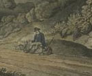 The
series of American views by the London firm Atkins & Nightingale are distinguished
by majestic trees, lush greenery, and rolling hills, all skillfully rendered
in aquatint. Aquatint was introduced to England in the 1770s by watercolorist
Paul Sandby as a printmaking medium effective in capturing tonal effects.
It was put to immediate use in several major English publications of American
views, including The Atlantic Neptune. English artists transmitted
this technique to the United States and produced such masterpieces as John
Hill’s portfolios, Picturesque Views of American Scenery (after
Joshua Shaw, 1819–21; an unpublished view of Boston from the series
is on view in this exhibition) and the Hudson River Portfolio (after
William Guy Wall, 1821–25), and William James Bennett’s series
of separately issued city views. By the mid-1850s, lithography had replaced
aquatint as a quicker and easier tonal method of printing.
The
series of American views by the London firm Atkins & Nightingale are distinguished
by majestic trees, lush greenery, and rolling hills, all skillfully rendered
in aquatint. Aquatint was introduced to England in the 1770s by watercolorist
Paul Sandby as a printmaking medium effective in capturing tonal effects.
It was put to immediate use in several major English publications of American
views, including The Atlantic Neptune. English artists transmitted
this technique to the United States and produced such masterpieces as John
Hill’s portfolios, Picturesque Views of American Scenery (after
Joshua Shaw, 1819–21; an unpublished view of Boston from the series
is on view in this exhibition) and the Hudson River Portfolio (after
William Guy Wall, 1821–25), and William James Bennett’s series
of separately issued city views. By the mid-1850s, lithography had replaced
aquatint as a quicker and easier tonal method of printing.
15
Plan of the City of Washington in the Territory of Columbia
Samuel Hill (American, 1766?–1804), surveyed by Andrew Ellicott (American,
1754–1820)
Etching and engraving, 1792
Deák 190
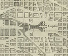 In
July 1790, Washington, D.C., was officially named the seat of the federal
government. Philadelphia served as the federal meeting place for the next
ten years while the planning and construction of the new capital was under
way. President George Washington selected the site on the Potomac and enlisted
the French architect and Revolutionary War veteran Pierre-Charles L’Enfant
to design the city.
In
July 1790, Washington, D.C., was officially named the seat of the federal
government. Philadelphia served as the federal meeting place for the next
ten years while the planning and construction of the new capital was under
way. President George Washington selected the site on the Potomac and enlisted
the French architect and Revolutionary War veteran Pierre-Charles L’Enfant
to design the city.
After numerous delays in the printing of L’Enfant’s plan, Andrew
Ellicott prepared a version based on the original design, which was turned
over to the well-known Boston engraver Samuel Hill. By the time of the second
public sale of lots in October 1792, 4,000 impressions of this print were
available to potential buyers.
16
View of Washington City and Georgetown
Edward Weber & Co. (Baltimore lithographic firm, 1835–54)
Tinted lithograph with hand-coloring, published by Casimir Bohn, 1849
Deák 577
 This
lithograph is the first separately issued print to show the growing city from
the portico of the Capitol, a vantage point that became a favorite with Washington,
D.C., view-makers. Surrounding the main view are twenty vignettes, including
a projection of the Smithsonian Institution, which had recently begun construction,
and a depiction of the Washington Monument with its planned, although never
constructed, pantheon base. Publisher Casimir Bohn issued this print separately,
and also included it in a guidebook to the city.
This
lithograph is the first separately issued print to show the growing city from
the portico of the Capitol, a vantage point that became a favorite with Washington,
D.C., view-makers. Surrounding the main view are twenty vignettes, including
a projection of the Smithsonian Institution, which had recently begun construction,
and a depiction of the Washington Monument with its planned, although never
constructed, pantheon base. Publisher Casimir Bohn issued this print separately,
and also included it in a guidebook to the city.
17
View of Washington
Edward Sachse (American, 1804–1873), after his own design
Color lithograph with hand-coloring, printed and published by E. Sachse &
Co. (Baltimore lithographic firm, 1851–66), 1852
Deák 635
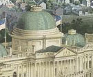 Baltimore
printer and publisher Edward Sachse issued several large lithographs of Washington,
D.C., beginning with this aerial view of the Capitol. Sachse drew this view
himself, imagining how the two new wings of the building, authorized in 1851,
might appear when completed. He also provided a glimpse of how the Mall might
have appeared if it had been laid out according to landscape architect Andrew
Jackson Downing’s proposal for curving paths and naturalistic plantings.
Baltimore
printer and publisher Edward Sachse issued several large lithographs of Washington,
D.C., beginning with this aerial view of the Capitol. Sachse drew this view
himself, imagining how the two new wings of the building, authorized in 1851,
might appear when completed. He also provided a glimpse of how the Mall might
have appeared if it had been laid out according to landscape architect Andrew
Jackson Downing’s proposal for curving paths and naturalistic plantings.
Such views provide documentary evidence of the changes, realized or not,
that cities went through during their planning and growth and fulfill Stokes’s
aim of presenting a “pictorial outline of our country’s development.”
Note to the checklist. “Deák” refers
to the catalogue of American historical prints in the New York Public Library’s
collections: Deák, Gloria Gilda. Picturing America 1497-1899. Prints,
Maps, and Drawings bearing on the New World Discoveries and on the Development
of the Territory that is now the United States. 2 vols. Princeton: Princeton
University Press, 1988.
Next Section