Part I: Founding Cities
Maps
1
America noviter delineata
Jodocus Hondius (Dutch, 1563–1612)
Engraving, 1618
Deák 15
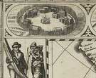 The flood of information about the New World, and the evolution of map production
in the 17th-century Netherlands, resulted in this decorative and informative
map of North and South America. When the firm of Jodocus Hondius, famous
for its reissues of Mercator’s Atlas, published this map around 1618,
the latest discoveries from the 1616 voyage around Cape Horn by the Dutch
navigator Willem Schouten were incorporated. Around the edges of the map,
views of individual cities and native peoples of the Americas offer a digest
of information about
the continents shown. Much like maps, prints depicting national and local
costume reflect a widespread European interest in defining and categorizing
the known world, which was, as this map indicates, expanding on a regular
basis.
The flood of information about the New World, and the evolution of map production
in the 17th-century Netherlands, resulted in this decorative and informative
map of North and South America. When the firm of Jodocus Hondius, famous
for its reissues of Mercator’s Atlas, published this map around 1618,
the latest discoveries from the 1616 voyage around Cape Horn by the Dutch
navigator Willem Schouten were incorporated. Around the edges of the map,
views of individual cities and native peoples of the Americas offer a digest
of information about
the continents shown. Much like maps, prints depicting national and local
costume reflect a widespread European interest in defining and categorizing
the known world, which was, as this map indicates, expanding on a regular
basis.
2
A View of the First Cities of the United States
John L. Bouqueta de Woiseri (American, active 1797–1817), after his
own design
Colored etching and aquatint, ca. 1817
Deák 270
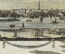 Urban
planning in the European settlements of the New World tended to mirror practices
from the Old World, including the choosing of sites close to prominent waterways.
Occupying some of the best natural harbors in the country, the cities represented
in this view became the commercial centers of the New World. At the turn of
the 19th century, John Bouqueta de Woiseri lived in New Orleans, where he
worked as an art teacher and “hair worker.” He traveled the country
making watercolor sketches of city profiles, many of which he used as the
basis for the views in this print (The Phelps Stokes Collection includes the
oversized gouache view of Philadelphia, and at least two other related drawings
are extant in public collections). Capturing most of the cities from unusual
angles, his drawings provided new topographical information.
Urban
planning in the European settlements of the New World tended to mirror practices
from the Old World, including the choosing of sites close to prominent waterways.
Occupying some of the best natural harbors in the country, the cities represented
in this view became the commercial centers of the New World. At the turn of
the 19th century, John Bouqueta de Woiseri lived in New Orleans, where he
worked as an art teacher and “hair worker.” He traveled the country
making watercolor sketches of city profiles, many of which he used as the
basis for the views in this print (The Phelps Stokes Collection includes the
oversized gouache view of Philadelphia, and at least two other related drawings
are extant in public collections). Capturing most of the cities from unusual
angles, his drawings provided new topographical information.
3
A Map of the States of Connecticut and Rhode Island with Part of New-York,
Massachusetts and New Jersey
Peter Maverick (American, 1780–1831), surveyed by John Randel, Jr. (1786?–1865)
Etching and engraving on satin, published by John Randel, Jr., 1821
Deák 327
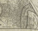 In
the autumn of 1810, John Randel completed nearly three years’ work on
an extensive survey of Manhattan in all its topographic detail, 11,400 acres
of it. The state-appointed Streets Commission had hired him to complete the
survey as part of a plan to regulate the city’s long-range growth up
the island. The Commissioners, however, had “public convenience and
benefit,” including health issues, in mind, and when the plan was published
in 1811, it displayed a rigidly enforced, geometric grid over much of the
island. A reprise of this plan can be seen at the center of this later regional
map by Randel, which includes not only clever trompe-l’oeil effects,
but also text and images explaining his tools and methods.
In
the autumn of 1810, John Randel completed nearly three years’ work on
an extensive survey of Manhattan in all its topographic detail, 11,400 acres
of it. The state-appointed Streets Commission had hired him to complete the
survey as part of a plan to regulate the city’s long-range growth up
the island. The Commissioners, however, had “public convenience and
benefit,” including health issues, in mind, and when the plan was published
in 1811, it displayed a rigidly enforced, geometric grid over much of the
island. A reprise of this plan can be seen at the center of this later regional
map by Randel, which includes not only clever trompe-l’oeil effects,
but also text and images explaining his tools and methods.
Peter Maverick engraved both the 1811 plan and this map. A prominent and
influential engraver, Maverick was one of the first generation of native printmakers
active in the United States. Stokes acquired this impression on satin from
Randel’s nephew.
4
Novi Belgii Novaeque Angliae nec non partis Virginiae tabula multis in
locis emendata
Colored etching and engraving, published by Claes Jansz Visscher, ca. 1656
Deák 42
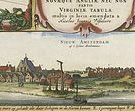 Based
on a map published in Amsterdam by Jan Jansson in 1651, this map of North
American settlements combines information from virtually all known maps of
the period, and was the most complete and accurate representation of its time.
Referred to by Stokes as “a cartographical encyclopedia,” it remained
a model for maps of the North American coast for the next century. Native
peoples, settlements, and fauna are scattered across the map, but Claes Jansz
Visscher further embellished his version with an inset view of New Amsterdam,
based on one of the earliest depictions of the city.
Based
on a map published in Amsterdam by Jan Jansson in 1651, this map of North
American settlements combines information from virtually all known maps of
the period, and was the most complete and accurate representation of its time.
Referred to by Stokes as “a cartographical encyclopedia,” it remained
a model for maps of the North American coast for the next century. Native
peoples, settlements, and fauna are scattered across the map, but Claes Jansz
Visscher further embellished his version with an inset view of New Amsterdam,
based on one of the earliest depictions of the city.
The dating and source of the inset view of New Amsterdam has long been a
point of contention. The etching may have served the purpose, much like the
later 19th-century views, of advertising the colony to potential settlers.
Prominently placed on the map, which reaches from Virginia up through New
England to the St. Lawrence River, it also promoted the centrality of New
Netherland on the eastern coast of North America.
Note to the checklist. “Deák” refers
to the catalogue of American historical prints in the New York Public Library’s
collections: Deák, Gloria Gilda. Picturing America 1497-1899. Prints,
Maps, and Drawings bearing on the New World Discoveries and on the Development
of the Territory that is now the United States. 2 vols. Princeton: Princeton
University Press, 1988.
Next Section