Part II: Settlement, Expansion, and the Business
of City Views
Canadian Cities
66
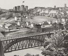
View of Victoria, Vancouver Island
Thomas Picken (British, d. 1870), after Hermann Otto Tiedemann (Canadian,
b. Germany, 1821)
Color lithograph, printed and published by Day & Son (London lithographic
firm, 19th century), 1860
Deák 751
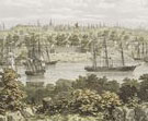 Located
on the southern tip of Vancouver Island, Victoria was founded by the Hudson’s
Bay Company in 1843. It served as capital of the Vancouver Island colony from
1848, and was capital of all of British Columbia when it became a Canadian
province in 1871. The gold strike of 1858 drew many people to this attractive
port on the Pacific Ocean, and the city grew accordingly. Hermann Otto Tiedemann
was one of those who contributed to the city’s growth, acting as a surveyor,
civil engineer, and architect for many public works projects. In his drawing,
one of the last views to depict historic Fort Victoria, Tiedemann pictured
the growing skyline and busy port from the vantage of the former village of
the Songhees, a First Nations tribe.
Located
on the southern tip of Vancouver Island, Victoria was founded by the Hudson’s
Bay Company in 1843. It served as capital of the Vancouver Island colony from
1848, and was capital of all of British Columbia when it became a Canadian
province in 1871. The gold strike of 1858 drew many people to this attractive
port on the Pacific Ocean, and the city grew accordingly. Hermann Otto Tiedemann
was one of those who contributed to the city’s growth, acting as a surveyor,
civil engineer, and architect for many public works projects. In his drawing,
one of the last views to depict historic Fort Victoria, Tiedemann pictured
the growing skyline and busy port from the vantage of the former village of
the Songhees, a First Nations tribe.
There is a minor dispute as to the source of this lithograph: the 1933 collection
catalogue notes that it was in the Tiedemann family’s possession until
Stokes acquired it from the artist’s son. But Stokes’s correspondence
with the architect Albertson in Seattle includes a letter from Harold Bernard,
the young journalist who helped Albertson locate potential purchases for Stokes.
He says that after asking at the local historical society, he contacted a
Mr. W. H. Bone who had lived in Victoria since 1862. Mr. Bone was said to
be a “personal friend” of Tiedemann. Reluctant initially to part
with the print, Bone consented in the belief that he would “help complete
a work of merit.”
67
Quebec, the Capital of New-France, a Bishoprick, and Seat on the Soverain
Court
Thomas Johnston (American, ca. 1708–1767), after François Chéreau
(French, 1680–1729) and Nicolas de Fer (French, 1646–1720)
Colored engraving and etching, printed by Thomas Johnston, published by Stephen
Whiting, 1759
Deák 78
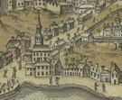 This
engraving by Thomas Johnston is the earliest American-produced view of Quebec.
It was issued upon the victory of British forces against the French, who had
occupied Quebec since its founding in 1608, marking the end of the French
and Indian War. Johnston hailed from Boston where he was a true jack-of-all-trades,
working at various times as a decorator, builder, housepainter, church singer,
song-book publisher, organ builder, and engraver. He based his view on a print
by François Chéreau, engraver to the King of France. Chéreau
had based his own view on an inset in a map by Nicolas de Fer, published in
1718 in La France Occidentale dans l’Amérique Septentrionale.
De Fer was a prolific cartographer who published three major atlases known
for their beautiful, if not entirely accurate, renderings.
This
engraving by Thomas Johnston is the earliest American-produced view of Quebec.
It was issued upon the victory of British forces against the French, who had
occupied Quebec since its founding in 1608, marking the end of the French
and Indian War. Johnston hailed from Boston where he was a true jack-of-all-trades,
working at various times as a decorator, builder, housepainter, church singer,
song-book publisher, organ builder, and engraver. He based his view on a print
by François Chéreau, engraver to the King of France. Chéreau
had based his own view on an inset in a map by Nicolas de Fer, published in
1718 in La France Occidentale dans l’Amérique Septentrionale.
De Fer was a prolific cartographer who published three major atlases known
for their beautiful, if not entirely accurate, renderings.
68
A View of Louisbourg in North America
Pierre-Charles Canot (French, 1710–1777), after Charles Ince (British,
18th century)
Colored etching, from Scenographia Americana, published by John Bowles,
Robert Sayer, Thomas Jefferys, Carington Bowles, and Henry Parker, 1768
Deák 108
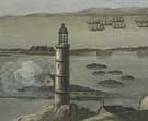 The
Scenographia Americana is a series of twenty-eight views of North
America and the West Indies. Issued in London, it featured the sites and events
of the French and Indian War. As stated on the title page, the views were
etched “From Drawings taken on the spot, by several officers of the
British Navy and Army.”
The
Scenographia Americana is a series of twenty-eight views of North
America and the West Indies. Issued in London, it featured the sites and events
of the French and Indian War. As stated on the title page, the views were
etched “From Drawings taken on the spot, by several officers of the
British Navy and Army.”
Captain Charles Ince drew this scene of Louisbourg, on the southeast coast
of Nova Scotia. Under the French, the city was heavily fortified to control
access to the Gulf of St. Lawrence. It had briefly come under British control
in 1745 when it was captured by New Englanders under the leadership of Sir
William Pepperell, and fell completely to the British in 1758. This scene,
along with the others in the series, aimed to celebrate Britain’s victories
and growing empire.
69
An East View of Montreal, in Canada
Pierre-Charles Canot (French, 1710–1777), after Thomas Patten (British,
18th century)
Etching, from Scenographia Americana, published by John Bowles, Robert
Sayer, Thomas Jefferys, Carington Bowles, and Henry Parker, 1768
Deák 111
 The
French and Indian War concluded with the battle for Montreal. British officer
Thomas Patten recorded this momentous occasion, which led to the permanent
end of French control of Canada. This view, like the view of Louisbourg
(see
number 68), was part of the Scenographia Americana, a series of
twenty-eight views by British officers. First issued as individual prints
in 1762, they
were published as a set in 1768. An ambitious undertaking, the series was
promoted by five London publishers. An expanded series totaling seventy-four
views was later published under the same title. The series was very popular
and served as the basis for many subsequent views and book illustrations
published
in the United States.
The
French and Indian War concluded with the battle for Montreal. British officer
Thomas Patten recorded this momentous occasion, which led to the permanent
end of French control of Canada. This view, like the view of Louisbourg
(see
number 68), was part of the Scenographia Americana, a series of
twenty-eight views by British officers. First issued as individual prints
in 1762, they
were published as a set in 1768. An ambitious undertaking, the series was
promoted by five London publishers. An expanded series totaling seventy-four
views was later published under the same title. The series was very popular
and served as the basis for many subsequent views and book illustrations
published
in the United States.
70
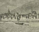
London, Canada West
After Edwin Whitefield (American, b. England, 1816–1892)
Tinted lithograph, from Whitefield’s Original Views of North American
Cities, published by Edwin Whitefield, 1855
Deák 695
 A
pioneer in the field of self-promotion, Edwin Whitefield traveled throughout
North America as an itinerant view-maker. He had a strong affinity for Canada,
moving his family there in 1853, and some of his best and most successful
views are of that country. Much of his time was spent on the business side
of art production, as recorded in his diaries. He noted that he spent one
day walking 26 miles in five hours in pursuit of Canadian subscribers for
his lithographs. Realizing the need for help, he was one of the first artists
to employ subscription agents, hiring the Smith Brothers and James Palmatary,
who later established their own prominent firms. This view of London, Ontario,
was one of forty-nine views included in his series Whitefield’s
Original Views of North American Cities, which he self-published between
1845 and 1857.
A
pioneer in the field of self-promotion, Edwin Whitefield traveled throughout
North America as an itinerant view-maker. He had a strong affinity for Canada,
moving his family there in 1853, and some of his best and most successful
views are of that country. Much of his time was spent on the business side
of art production, as recorded in his diaries. He noted that he spent one
day walking 26 miles in five hours in pursuit of Canadian subscribers for
his lithographs. Realizing the need for help, he was one of the first artists
to employ subscription agents, hiring the Smith Brothers and James Palmatary,
who later established their own prominent firms. This view of London, Ontario,
was one of forty-nine views included in his series Whitefield’s
Original Views of North American Cities, which he self-published between
1845 and 1857.
Note to the checklist. “Deák” refers
to the catalogue of American historical prints in the New York Public Library’s
collections: Deák, Gloria Gilda. Picturing America 1497-1899. Prints,
Maps, and Drawings bearing on the New World Discoveries and on the Development
of the Territory that is now the United States. 2 vols. Princeton: Princeton
University Press, 1988.
Next Section