Part II: Settlement, Expansion, and the Business
of City Views
Far Western Cities
58
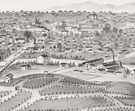
Great Salt Lake City in 1853. Looking South
Frederick Hawkins Piercy (British, 1830–1891)
Pen and ink and wash, preparatory drawing for Route from Liverpool to
Great Salt Lake Valley, 1853
Deák 653
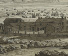
Frederick
Hawkins Piercy was commissioned by the Mormons in his native England to make
drawings along a pilgrimage route to Salt Lake City. Two years later, the
illustrated Route from Liverpool to Great Salt Lake Valley appeared,
including his journal of the trip as well as “an authentic history of
the Latter-day Saints’ emigration from Europe” by James Linforth.
It traces his journey from his arrival in New Orleans, via a steamboat up
the Mississippi to Missouri, then overland through Iowa to his destination
in Utah. Many of his drawings were done with the aid of a camera lucida, an
optical device in which a reflecting glass prism allows the artist looking
through it to “see” and trace a faint reflection of the object
on the paper. It typically produces crisp, luminous quality, as seen in this
drawing.
About this view, Piercy wrote: “The view of the City was taken with
a camera lucida, from the ‘Bench,’ north of [the city], and just
above President H. C. Kimball’s house, which is seen in the foreground….
The site of the city is large, and at that early period the buildings were
very much scattered, rendering it almost impossible to convey any idea of
the place unless a large area was embraced in the view.”
59
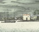
Great Salt Lake, Utah
Currier and Ives (New York lithographic firm, 1857–1907)
Colored lithograph, published by Currier and Ives, ca. 1870
Deák 829
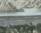 The
Church of Jesus Christ of Latter-Day Saints was founded by Joseph Smith in
1830. After Smith and his followers, known as Mormons, were driven out of
several states, violence erupted in Illinois and Smith was killed in 1844.
Brigham Young emerged as the new leader and in 1847 led the remaining Mormons
on a march west, settling in Utah near the Great Salt Lake, establishing the
first permanent settlement in the territory.
The
Church of Jesus Christ of Latter-Day Saints was founded by Joseph Smith in
1830. After Smith and his followers, known as Mormons, were driven out of
several states, violence erupted in Illinois and Smith was killed in 1844.
Brigham Young emerged as the new leader and in 1847 led the remaining Mormons
on a march west, settling in Utah near the Great Salt Lake, establishing the
first permanent settlement in the territory.
Currier and Ives ran the most prodigious and successful lithographic printing
firm of the 19th century. They issued over 7,000 prints, in editions often
running into the hundreds of thousands. Most were inexpensive and picturesque,
ranging from scenes of animals, sports, and rural life to current events and
religious scenes.
60
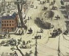
Virginia City, Nevada Territory
Charles Conrad Kuchel (American, b. Germany, 1820–1866), after Grafton
Tyler Brown (American, 1841–1918)
Tinted lithograph, published by Grafton Tyler Brown, 1861
Deák 771
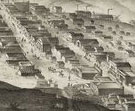 Grafton
Tyler Brown left his native Pennsylvania before he was twenty and arrived
in San Francisco, becoming the first African American printmaker to work in
California. He worked for the firm Kuchel and Dresel, which was busy in the
1850s issuing views of western cities that carefully recorded the early layouts
of Gold Rush settlements. In 1859, gold and more significantly silver were
discovered in Nevada, and the miners settled in the quickly laid out Virginia
City, which was incorporated in 1861. It was first part of Utah Territory,
and then the newly organized Nevada Territory, which quickly became a state
in 1864.
Grafton
Tyler Brown left his native Pennsylvania before he was twenty and arrived
in San Francisco, becoming the first African American printmaker to work in
California. He worked for the firm Kuchel and Dresel, which was busy in the
1850s issuing views of western cities that carefully recorded the early layouts
of Gold Rush settlements. In 1859, gold and more significantly silver were
discovered in Nevada, and the miners settled in the quickly laid out Virginia
City, which was incorporated in 1861. It was first part of Utah Territory,
and then the newly organized Nevada Territory, which quickly became a state
in 1864.
Views such as this one were probably intended at least in part for sale to
the miners flooding the area, who could use them as souvenirs for themselves
or for family and friends back home. This print is inscribed “To Catharine
Clark, from her affectionate brother Smythe Clark. Mr. Clark Boards here.
B Street. You will find the house on the map thus marked #” –
the mark appears before the three-story building in the center of the town.
61
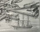
San-Francisco
Arvah J. Ibbotson (American, 19th century), after Henry Firks (American, 19th
century)
Tinted lithograph, printed by Thomas S. Sinclair’s Lithography (Philadelphia
lithographic firm, 1849–53), published by W. H. Jones, 1849
Deák 584
 The
discovery of gold in California in 1848 initiated a wave of westward-bound
prospectors. Henry Firks was the first artist to capture San Francisco in
the wake of this momentous occasion. He pictured the city spread out beneath
Montgomery Hill and looking toward Telegraph Hill. Forty-five points of interest
are labeled, primarily identifications of the many vessels dotting San Francisco
Bay.
The
discovery of gold in California in 1848 initiated a wave of westward-bound
prospectors. Henry Firks was the first artist to capture San Francisco in
the wake of this momentous occasion. He pictured the city spread out beneath
Montgomery Hill and looking toward Telegraph Hill. Forty-five points of interest
are labeled, primarily identifications of the many vessels dotting San Francisco
Bay.
Thomas S. Sinclair, a Philadelphia publisher, beat out his competition to
publish this view, one of the first of San Francisco during the gold rush.
It was extremely popular, and was issued eight times, the last in 1886. Numerous
other artists used it as the basis for their own views.
62
View of Los Angeles from the East
After Eli Sheldon Glover (American, 1845–1919)
Tinted lithograph, printed by A. L. Bancroft & Company (San Francisco
lithographic firm, 1872–90), published by Brooklyn Land and Building
Company, 1877
Deák 848
 Eli
Sheldon Glover began his career as a subscription agent for Albert Ruger,
an indefatigable lithographer who produced over 250 prints of towns and cities
in twenty-four states in as many years. In 1870, two years after establishing
his own firm in Chicago, the Merchants Lithographing Company, Glover picked
up a sketchbook and began his career as an itinerant artist. Around 1876 he
found himself living in Los Angeles and discussed with San Francisco printer
Albert Little Bancroft his plans for a series of California views, which probably
included this lithograph of Los Angeles.
Eli
Sheldon Glover began his career as a subscription agent for Albert Ruger,
an indefatigable lithographer who produced over 250 prints of towns and cities
in twenty-four states in as many years. In 1870, two years after establishing
his own firm in Chicago, the Merchants Lithographing Company, Glover picked
up a sketchbook and began his career as an itinerant artist. Around 1876 he
found himself living in Los Angeles and discussed with San Francisco printer
Albert Little Bancroft his plans for a series of California views, which probably
included this lithograph of Los Angeles.
Many traveling view-makers, most of whom spent their early careers in the
Midwest, came to the West Coast to meet the high demand for city views. Such
views were often used as advertisements or guides for prospective settlers,
and many artists adopted an aerial vantage to provide detailed and easily
legible layouts of these cities.
63
Vue du Port Hanarourou
Victor Vincent Adam (French, 1801–1866), after Louis Choris (Russian,
1795–1828)
Colored lithograph, printed by Langlumé & de l’Abbaye (Paris
lithographic firm, 19th century), from Voyage pittoresque autour du monde,
1822
Deák 297
 At
the age of twenty, artist Louis Choris was selected to go on the Russian
circumnavigation
voyage headed by Otto von Kotzebue between 1815 and 1818. Upon his return,
Choris published his sketches as Voyage pittoresque autour du monde,
which included some of the earliest views of the lands and peoples of the
Pacific. Choris’s drawings were lithographed by Victor Adam, one of
the earliest and most prolific practitioners of the emerging medium. Choris’s
views of Hawaii during the last years of the reign of Kamehameha I capture
the people unselfconsciously engaged in their daily activities, providing
an invaluable record of everyday life under the feudal system.
At
the age of twenty, artist Louis Choris was selected to go on the Russian
circumnavigation
voyage headed by Otto von Kotzebue between 1815 and 1818. Upon his return,
Choris published his sketches as Voyage pittoresque autour du monde,
which included some of the earliest views of the lands and peoples of the
Pacific. Choris’s drawings were lithographed by Victor Adam, one of
the earliest and most prolific practitioners of the emerging medium. Choris’s
views of Hawaii during the last years of the reign of Kamehameha I capture
the people unselfconsciously engaged in their daily activities, providing
an invaluable record of everyday life under the feudal system.
Hawaii became a U.S. territory in June 1900, but a state only in 1959. Stokes
included this view among the “foreign views.”
64
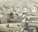
Sacramento City Ca. from the Foot of J. Street
After George Victor Cooper (American, 1810–1878)
Tinted lithograph with hand-coloring, printed by William Endicott & Co.
(New York lithographic firm, 1849–52), published by Stringer & Townsend,
ca. 1850
Deák 591
 Gold
was discovered at John Sutter’s sawmill near the Sacramento River in
1848, ushering in the era of gold rushes. George Victor Cooper, born in New
Jersey, was one of the many artists who headed west to capture these emerging
cities. His view, drawn on the spot in December 1849, displays the teeming
energy of the city, which had been surveyed and laid out in the previous two
years and served as winter quarters for the miners. Printed by William Endicott
& Company, the foremost New York lithographic firm, this print is the
earliest view of the city.
Gold
was discovered at John Sutter’s sawmill near the Sacramento River in
1848, ushering in the era of gold rushes. George Victor Cooper, born in New
Jersey, was one of the many artists who headed west to capture these emerging
cities. His view, drawn on the spot in December 1849, displays the teeming
energy of the city, which had been surveyed and laid out in the previous two
years and served as winter quarters for the miners. Printed by William Endicott
& Company, the foremost New York lithographic firm, this print is the
earliest view of the city.
65
Bird’s Eye View of the City of Seattle, WT.
After Henry Wellge (American, b. Germany, 1850–1917)
Tinted lithograph, printed by Beck and Pauli (Milwaukee lithographic firm,
1876–89), published by Joseph John Stoner, 1884
Deák 873
 After
the Civil War, the Midwest became a leading center of American lithographic
production. This prominence was due to the large number of German settlers
in the area, such as the prolific Beck and Pauli, who brought their expertise
from Germany, the birthplace of lithography in 1796. They printed views of
cities and towns across the United States, especially in the West, which was
experiencing a population-boom in the second half of the 19th century. This
aerial shot of Seattle was drawn by Henry Wellge, a fellow German-born Midwesterner
who drew panoramic maps and views throughout the country.
After
the Civil War, the Midwest became a leading center of American lithographic
production. This prominence was due to the large number of German settlers
in the area, such as the prolific Beck and Pauli, who brought their expertise
from Germany, the birthplace of lithography in 1796. They printed views of
cities and towns across the United States, especially in the West, which was
experiencing a population-boom in the second half of the 19th century. This
aerial shot of Seattle was drawn by Henry Wellge, a fellow German-born Midwesterner
who drew panoramic maps and views throughout the country.
Although it was already a bustling port city, Seattle grew in importance
after the 1897 discovery of gold in Alaska and Yukon Territory. Stokes was
particularly eager to procure a view of this important Northwest city, and
as the catalogue of his collection was being prepared, he solicited the help
of architect A. H. Albertson, who was working in Seattle. Albertson and a
young journalist friend of his put ads in the local papers and contacted local
historical societies, managing to locate this view owned by “an old
pioneer family.” Stokes hesitated at first, because he wanted to have
the earliest views possible (an 1879 view, incomplete and in poor condition,
was refused), but acquiesced when he realized that he would not be able to
do better on short notice.
Note to the checklist. “Deák” refers
to the catalogue of American historical prints in the New York Public Library’s
collections: Deák, Gloria Gilda. Picturing America 1497-1899. Prints,
Maps, and Drawings bearing on the New World Discoveries and on the Development
of the Territory that is now the United States. 2 vols. Princeton: Princeton
University Press, 1988.
Next Section