Part II: Settlement, Expansion, and the Business
of City Views
Southeastern Cities
30
Plan von Neu Ebenezer
Colored etching and engraving, from Samuel Urlsperger, Ausfürhliche
Nachrichten von den saltzburgischen emigranten, published by Matthaeus Seutter,
1747
Deák 95
 Many
of the first American colonists were religious refugees fleeing persecution
in Europe. The Salzburgers were a group of Lutherans who were exiled from
their homeland in Salzburg, Austria. In 1734, the English “Society for
Promoting Christian Knowledge” sponsored the sea passage of a small
number of them to America. Their first settlement, on the Ebenezer River,
proved inhospitable, so in 1736 they moved to the banks of the Savannah River,
where they founded New Ebenezer. With Savannah, founded only three years earlier,
as a model, New Ebenezer was laid out in a grid pattern punctuated by open
squares and became a thriving locale known for its silk trade. It is now an
archaeological site listed on the National Register of Historic Places; only
the brick Jerusalem Lutheran Church and a few other buildings survive.
Many
of the first American colonists were religious refugees fleeing persecution
in Europe. The Salzburgers were a group of Lutherans who were exiled from
their homeland in Salzburg, Austria. In 1734, the English “Society for
Promoting Christian Knowledge” sponsored the sea passage of a small
number of them to America. Their first settlement, on the Ebenezer River,
proved inhospitable, so in 1736 they moved to the banks of the Savannah River,
where they founded New Ebenezer. With Savannah, founded only three years earlier,
as a model, New Ebenezer was laid out in a grid pattern punctuated by open
squares and became a thriving locale known for its silk trade. It is now an
archaeological site listed on the National Register of Historic Places; only
the brick Jerusalem Lutheran Church and a few other buildings survive.
31
Saint Augustine
Engraving, from Walter Bigges, A Summarie and True Discourse of Sir Frances
Drakes West Indian Voyage, 1588
Deák 12
 This
aerial view of St. Augustine is probably the earliest engraving of a city
within the United States. Originally visited by Ponce de Leon in 1513, the
site of St. Augustine was settled by the Spaniards in 1565 as a base to
safeguard
their Caribbean holdings. Twenty-one years later, Sir Francis Drake arrived
and burned the settlement to the ground. This engraving was included in
a
1588 account of Drake’s raids, Walter Bigges’s A Summarie
and True Discourse of Sir Frances Drakes West Indian Voyage.
This
aerial view of St. Augustine is probably the earliest engraving of a city
within the United States. Originally visited by Ponce de Leon in 1513, the
site of St. Augustine was settled by the Spaniards in 1565 as a base to
safeguard
their Caribbean holdings. Twenty-one years later, Sir Francis Drake arrived
and burned the settlement to the ground. This engraving was included in
a
1588 account of Drake’s raids, Walter Bigges’s A Summarie
and True Discourse of Sir Frances Drakes West Indian Voyage.
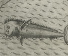
Large sea creatures are featured in all of the plates in this account, and
a dolphin is seen here in the lower left corner. According to the inscription,
“he is very pleasant to behold in the sea by day light, and in the night
he seemeth to be of the coullour of gold, he taketh pleasure as other fishes
do by swimming by the ship, he is excellent sweete to be eaten.”
32
Savannah, Ga.
Charles Parsons (American, b. England, 1821–1910), after John William
Hill (American, b. England, 1812–1879)
Lithograph, printed by Endicott & Co. (New York lithographic firm, active
1852–86), ca. 1856
Deák 704
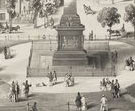 Savannah,
founded in 1733, was unlike most new cities in the United States. It had no
central square or defined boundaries, but was composed of a series of wards,
each with its own central open space, for which the city became famous. One
such space, Monterey Square, with its towering Pulaski Monument, is seen in
this lithograph after a view by John William Hill, son of the prominent printmaker
John Hill.
Savannah,
founded in 1733, was unlike most new cities in the United States. It had no
central square or defined boundaries, but was composed of a series of wards,
each with its own central open space, for which the city became famous. One
such space, Monterey Square, with its towering Pulaski Monument, is seen in
this lithograph after a view by John William Hill, son of the prominent printmaker
John Hill.
In the 1850s, the younger Hill was commissioned to produce a series of city
views for the New York print publishers Smith Brothers and Company. They employed
the printing firm Endicott and Company, where Charles Parsons was an employee,
to print these views. Parsons had a long career as a lithographer, beginning
at age twelve as an apprentice to George Endicott.
33
Plan of the City and Suburbs of New Orleans
William Rollinson (American, b. England, 1762–1842), surveyed by Jacques
Tanesse (American?, 19th century)
Colored etching and engraving, published by P. Maspero and Charles Del Vecchio,
1817
Deák 292
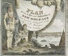 Situated
on a dramatic bend in the Mississippi River, New Orleans became known as the
Crescent City. Founded in 1718 by Jean Baptiste Le Moyne, Sieur de Bienville,
it was named in honor of the Duc d’Orléans. As part of the Louisiana
Territory, it was ceded to Spain in 1763, returned to France in 1800, and
sold to America three years later. Shortly before this plan was drawn, the
United States army, led by General Andrew Jackson, defeated the British at
the Battle of New Orleans, marking the symbolic end to the War of 1812. The
fortifications ordered by General Jackson are shown on Tanesse’s survey,
in the lower right corner.
Situated
on a dramatic bend in the Mississippi River, New Orleans became known as the
Crescent City. Founded in 1718 by Jean Baptiste Le Moyne, Sieur de Bienville,
it was named in honor of the Duc d’Orléans. As part of the Louisiana
Territory, it was ceded to Spain in 1763, returned to France in 1800, and
sold to America three years later. Shortly before this plan was drawn, the
United States army, led by General Andrew Jackson, defeated the British at
the Battle of New Orleans, marking the symbolic end to the War of 1812. The
fortifications ordered by General Jackson are shown on Tanesse’s survey,
in the lower right corner.
In 1812, city surveyor Jacques Tanesse was commissioned by the city council
to draw up a plan of the city with a view toward expansion. That plan included
the original rectangular French Quarter set on the curve of the Mississippi,
and plotted out recently established suburbs. The first of these, in 1788,
was the Faubourg Ste. Marie on the former plantation of Bertrand and Marie
Gravier, just to the left of the French Quarter (a reduced “habitation
Gravier” can be seen on this plan), aimed at the non-French population.
This was followed in 1805 by the Faubourg Marigny, on the other side of the
French Quarter, on the plantation of Bernard Xavier Philippe de Marigny de
Mandeville, aimed at the Creole population. By 1815, when Tanesse prepared
the survey shown in this elaborate engraved plan, clearly more neighborhoods
were called for: the new plan covers about four times the area of the first
one. By 1850, the population of New Orleans had grown to more than twenty
times its population in 1800: from 8,000 to 170,000.
34
New Orleans, Taken from the Opposite Side a Short Distance Above the Middle
or Picayune Ferry
William James Bennett (American, b. England, 1787–1844), after Anthony
Mondelli (American, b. Italy, ca. 1799)
Colored etching and aquatint, published by Henry Megarey, 1841
Deák 512
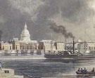 The
Italian artist Anthony Mondelli came to New Orleans in 1821 and for the next
thirty-three years taught art, operated an art store, and painted signs and
stage scenery. He also sketched this portside view of New Orleans enveloped
by a cloud-filled sky. Although William James Bennett traveled to many locales
for his city views, he never visited New Orleans and based his aquatint on
Mondelli’s drawing. Bennett’s series of American city views were
issued individually by various publishers, including Henry Megarey of New
York.
The
Italian artist Anthony Mondelli came to New Orleans in 1821 and for the next
thirty-three years taught art, operated an art store, and painted signs and
stage scenery. He also sketched this portside view of New Orleans enveloped
by a cloud-filled sky. Although William James Bennett traveled to many locales
for his city views, he never visited New Orleans and based his aquatint on
Mondelli’s drawing. Bennett’s series of American city views were
issued individually by various publishers, including Henry Megarey of New
York.
Note to the checklist. “Deák” refers
to the catalogue of American historical prints in the New York Public Library’s
collections: Deák, Gloria Gilda. Picturing America 1497-1899. Prints,
Maps, and Drawings bearing on the New World Discoveries and on the Development
of the Territory that is now the United States. 2 vols. Princeton: Princeton
University Press, 1988.
Next Section