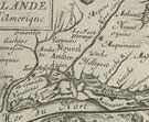
Part I: Founding Cities
Manhattan Island
Giovanni da Verrazzano was the first European to record his visit, in 1524,
to the New York Harbor, where he reported an enthusiastic greeting by feather-clad
Lenapes. It was only after Henry Hudson passed through in the Dutch East
India Company ship The Half Moon in 1609, however, that European
settlers came to stay. New Netherland colony was settled in 1624, and New
Amsterdam
was founded at the tip of Manhattan Island in 1626. In March 1664, the English
King put the Duke of York in charge of New Netherland, which had been surrounded
from the start by competitive English colonies, and the Dutch surrendered
the colony in September. The future New York City came to benefit from its
strategic position in the life of the colonies. British forces occupied it
during the Revolution (the Montresor plan was prepared for the British General
Gage). After a brief interlude as the Republic’s first capital from
1785-1790, the city's population nearly quadrupled in population between
1790 and 1820, and New
York
established itself as an important commercial link between the outside world
and the rest of America with the opening of the Erie Canal in 1825.
Stokes compiled his peerless Iconography of Manhattan Island over
twenty years, with a small cadre of assistants on both sides of the Atlantic.
It is a stunningly detailed physical account of the city in period maps, views,
and documents. During years of self-described feverish activity, he managed
to track down and buy impressions of many of the prints illustrated in the
book. These images form the core of his American historical print collection.
The New York prints on exhibition here are a tiny sampling of those used by
Stokes to write his history of the island, but they represent a cross section
of the whole, from early Dutch printed and drawn views to a Revolutionary
city plan, to a late 19th-century bird’s-eye view; and from the completely
“fictitious” French Nowel Amsterdam to the aquatint views
from The Atlantic Neptune, one of the most accurate marine atlases
of its time.
5
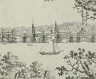
Novum Amsterodamum
Pen-and-ink and wash drawing, ca. 1642–43
Deák 33
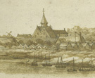 Many
early American views are anonymous and undated, like this watercolor of New
Amsterdam. The inclusion of certain architectural features can provide a key
to the dating of such works, which is often hotly contested. In this view,
both the local church and its belfry, completed in 1643, are visible, but
the tavern, thought to have begun construction in 1642, is absent. Although
a permit for it was issued in 1642, the construction of the tavern perhaps
did not begin until 1643, which might explain why the church is complete but
the tavern absent in this drawing.
Many
early American views are anonymous and undated, like this watercolor of New
Amsterdam. The inclusion of certain architectural features can provide a key
to the dating of such works, which is often hotly contested. In this view,
both the local church and its belfry, completed in 1643, are visible, but
the tavern, thought to have begun construction in 1642, is absent. Although
a permit for it was issued in 1642, the construction of the tavern perhaps
did not begin until 1643, which might explain why the church is complete but
the tavern absent in this drawing.
6
Nowel Amsterdam en l’Amerique
François Jollain (French, ca. 1641–1704)
Etching and engraving, possibly from Vues à vol d’oiseau
de différents villes de France et de pays étrangers, ca.
1672
Deák 52
 Pictures
of the New World were eagerly sought by a curious European audience. Print
publishers quickly capitalized on this demand by recycling existing European
views and presenting them as portrayals of the overseas colonies. This engraving
of New York City is one such fictitious view; it is actually a view of Lisbon,
Portugal, based on a print from a century earlier. François Jollain,
one of a family of French engravers, made little effort to transform the setting
into an authentic rendering, perhaps relying on his audience’s unfamiliarity
with American geography. The numbering in the lower right corner suggests
that this view was part of a series, perhaps Jollain’s Vues à
vol d’oiseau de différents villes de France et de pays étrangers.
Pictures
of the New World were eagerly sought by a curious European audience. Print
publishers quickly capitalized on this demand by recycling existing European
views and presenting them as portrayals of the overseas colonies. This engraving
of New York City is one such fictitious view; it is actually a view of Lisbon,
Portugal, based on a print from a century earlier. François Jollain,
one of a family of French engravers, made little effort to transform the setting
into an authentic rendering, perhaps relying on his audience’s unfamiliarity
with American geography. The numbering in the lower right corner suggests
that this view was part of a series, perhaps Jollain’s Vues à
vol d’oiseau de différents villes de France et de pays étrangers.
7
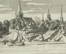
Nieu Amsterdam
Etching, ca. 1700
Deák 32
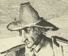 Based
on an early view of New Amsterdam, this etching shows the city as a backdrop
for mercantile activity. Although many of the prominent architectural features
on the southern tip of the island have been condensed, they remain identifiable
and were used by Stokes to date the view depicted in this late 17th-century
print to around 1642–43.
Based
on an early view of New Amsterdam, this etching shows the city as a backdrop
for mercantile activity. Although many of the prominent architectural features
on the southern tip of the island have been condensed, they remain identifiable
and were used by Stokes to date the view depicted in this late 17th-century
print to around 1642–43.
The setting, however, is overshadowed by two large figures – the same
that are identified as “English Quakers” in a view of Barbados
for the series Orbis habitabilis published by Carel Allard (see other
views from this series, of New York, below, and Panama and Havana, in the
second half of the exhibition). The gentleman grasps a handful of tobacco
leaves – a valuable New World commodity – and processed tobacco
on spindles appears at his feet. African slaves, like the ones in the middle
ground behind the tobacco merchant, were presumably present in New Netherland
at an early date, although the West India Company did not get involved in
large-scale slave trade until 1640, when Portugal lost its license to supply
slaves to the Spanish colonies.
8
Nieu Amsterdam at[que] New York
Aldert Meyer (Dutch, b. 1663 or 1664)
Colored etching and engraving, from Orbis habitabilis oppida et vestitus
[Cities and Costumes of the Inhabited World], published by Carel
Allard, ca. 1700
Deák 56
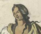 This
scene portrays New Amsterdam in 1673, when the Dutch briefly recaptured the
city from the Duke of York, who had taken possession of the colony nine years
earlier in the name of the King of England. The view was included in Amsterdam
publisher Carel Allard’s Orbis habitabilis oppida et vestitus,
which features one hundred views of cities around the world. The volume’s
foreword notes that since not everyone is able to learn about the world at
firsthand, the plates provide an “artful, accurate, and faithful”
image of cities all over the world, and with these images, anyone can “walk,
ride, and sail through them, even while sitting in the solitude of one’s
own room.”
This
scene portrays New Amsterdam in 1673, when the Dutch briefly recaptured the
city from the Duke of York, who had taken possession of the colony nine years
earlier in the name of the King of England. The view was included in Amsterdam
publisher Carel Allard’s Orbis habitabilis oppida et vestitus,
which features one hundred views of cities around the world. The volume’s
foreword notes that since not everyone is able to learn about the world at
firsthand, the plates provide an “artful, accurate, and faithful”
image of cities all over the world, and with these images, anyone can “walk,
ride, and sail through them, even while sitting in the solitude of one’s
own room.”
Each city is represented in the series by one topographical view, along with
another featuring a pair of large figures in local costume: the Native American
couple shown here provide tantalizing details of native dress and weaponry.
The furs at their side were coveted by the European market, and serve as a
reminder that New Netherland was established first and foremost as an outpost
for trade.
9
View of the City of New York Taken from Long Island
Charles-Balthazar-Julien Févret de Saint-Mémin (French, 1770–1852),
after his own design
Etching, 1796
Deák 215
 Charles-Balthazar-Julien
Févret de Saint-Mémin was born in Dijon, France, and fled his
homeland as an aristocratic refugee during the French Revolution. He arrived
in the United States in 1793 and became a hugely successful portrait artist.
With the help of two devices, the physionotrace, which enabled the human profile
to be precisely traced, and the pantograph, which reduced images, he created
miniature portraits of major figures, including the last lifetime portrait
of George Washington. Saint-Mémin used the same minute, precise draughtsmanship
for this rendering of the East River waterfront. Although diminutive, the
individual buildings are readily identifiable under magnification.
Charles-Balthazar-Julien
Févret de Saint-Mémin was born in Dijon, France, and fled his
homeland as an aristocratic refugee during the French Revolution. He arrived
in the United States in 1793 and became a hugely successful portrait artist.
With the help of two devices, the physionotrace, which enabled the human profile
to be precisely traced, and the pantograph, which reduced images, he created
miniature portraits of major figures, including the last lifetime portrait
of George Washington. Saint-Mémin used the same minute, precise draughtsmanship
for this rendering of the East River waterfront. Although diminutive, the
individual buildings are readily identifiable under magnification.
10
A View of New York from the North West
Etching and aquatint, from The Atlantic Neptune, published by Joseph
F. W. Des Barres, ca. 1777
Deák 130
 In
1763, the British Admiralty commissioned Joseph F. W. Des Barres to survey
and prepare a marine atlas of the coast of Nova Scotia. Over a period of nearly
twenty years, this project evolved into The Atlantic Neptune, a compendium
of charts, plans, and views of the entire East Coast of the North American
continent, all prepared under Des Barres’s supervision. Des Barres,
a French Huguenot who became an officer in the British Royal American Regiment
in 1755, developed strong ties in Canada. He spent eleven years surveying
the coasts of Nova Scotia, along with parts of New Brunswick and New England,
most of which had never been mapped in any detail. His attention to precision
ensured that his work would remain valid into the 19th century. In his introductory
text to the atlas, he remarked on the accuracy of his instruments, which he
was able to use only during the warmest six months of the year:
In
1763, the British Admiralty commissioned Joseph F. W. Des Barres to survey
and prepare a marine atlas of the coast of Nova Scotia. Over a period of nearly
twenty years, this project evolved into The Atlantic Neptune, a compendium
of charts, plans, and views of the entire East Coast of the North American
continent, all prepared under Des Barres’s supervision. Des Barres,
a French Huguenot who became an officer in the British Royal American Regiment
in 1755, developed strong ties in Canada. He spent eleven years surveying
the coasts of Nova Scotia, along with parts of New Brunswick and New England,
most of which had never been mapped in any detail. His attention to precision
ensured that his work would remain valid into the 19th century. In his introductory
text to the atlas, he remarked on the accuracy of his instruments, which he
was able to use only during the warmest six months of the year:
“The dangers to which the author has been exposed in the execution
of this important and arduous undertaking, as well as for the sake of greater
accuracy, perspicuity, and dispatch, put him to the necessity of furnishing
himself with repeated Sets of expensive Instruments, Astronomical and Geometrical;
constructed to his purpose, and rendered more perfect from the many Improvements
and Additions the long course of his Experience suggested….”
11
A Plan of the City of New-York & Its Environs to Greenwich on the
North or Hudsons River
Peter Andrews (active 1765–82), surveyed by John Montresor (American,
b. England, 1736–1799)
Engraving and etching, 1767
Deák 118
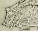 For
seven weeks during the height of the Stamp Act riots, in which the pre-Revolutionary
colonies organized to reject direct taxation from England, Lieutenant John
Montresor drafted a large map of Manhattan at the request of the commander-in-chief
of the British forces in the United States, General Thomas Gage. It was a
secret, and potentially dangerous, mission, as noted by Montresor in his journal:
“Continued on my Survey sub rosa as observation might endanger ones
house and effects if not ones life.” Owing to these mitigating circumstances,
including the speed with which it needed to be prepared, there are several
errors and omissions on the plan. This impression is an unfinished trial proof;
the published edition featured additional buildings, descriptions, and references,
as well as a title and cartouche. The map was reissued in 1775.
For
seven weeks during the height of the Stamp Act riots, in which the pre-Revolutionary
colonies organized to reject direct taxation from England, Lieutenant John
Montresor drafted a large map of Manhattan at the request of the commander-in-chief
of the British forces in the United States, General Thomas Gage. It was a
secret, and potentially dangerous, mission, as noted by Montresor in his journal:
“Continued on my Survey sub rosa as observation might endanger ones
house and effects if not ones life.” Owing to these mitigating circumstances,
including the speed with which it needed to be prepared, there are several
errors and omissions on the plan. This impression is an unfinished trial proof;
the published edition featured additional buildings, descriptions, and references,
as well as a title and cartouche. The map was reissued in 1775.
12
New-York. Taken from the Bay near Bedlows Island
William James Bennett (American, b. England, 1787–1844), after John
Gadsby Chapman (American, 1808–1889)
Color aquatint with hand-coloring, published by Henry Megarey, 1836
Deák 437
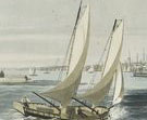 British-born
William James Bennett, one of the most accomplished masters of aquatint
active
in the United States in the early decades of the 19th century, made this
seascape as part of his series of nineteen views of American cities. Some
of the views
were executed after his own drawings, but several of them were done by contemporary
painters, such as this one by his colleague John Gadsby Chapman. Dominated
by rough water, the view is taken from Bedloe’s (now Liberty) Island
and ranges from Paulus Hook (now Jersey City), to Ellis Island, across Lower
Manhattan (with Trinity
Church
steeple centered between the boats), to Ellis Island, Governors Island, and
east to Brooklyn Heights.
British-born
William James Bennett, one of the most accomplished masters of aquatint
active
in the United States in the early decades of the 19th century, made this
seascape as part of his series of nineteen views of American cities. Some
of the views
were executed after his own drawings, but several of them were done by contemporary
painters, such as this one by his colleague John Gadsby Chapman. Dominated
by rough water, the view is taken from Bedloe’s (now Liberty) Island
and ranges from Paulus Hook (now Jersey City), to Ellis Island, across Lower
Manhattan (with Trinity
Church
steeple centered between the boats), to Ellis Island, Governors Island, and
east to Brooklyn Heights.
Chapman, like Bennett a member of the National Academy of Design, had a diverse
and distinguished artistic career. After studying at the Pennsylvania Academy
of Fine Arts and traveling to Italy to study the Old Masters, he returned
to the United States in 1831. He painted portraits and historical subjects,
and between 1837 and 1840 created his most famous painting, the Baptism
of Pocahontas, in the Rotunda of the United States Capitol. He was a
prolific illustrator, contributing over 1,400 illustrations to Harper’s
Illuminated Bible and publishing a successful artist’s manual,
The American Drawing-Book.
13
Panorama of New York and Vicinity
Julius Bien (New York lithographic firm, 1850–68), after John Bachmann
(American, b. Germany?, active 1849–77)
Chromolithograph, published by John Bachmann, 1866
Deák 807
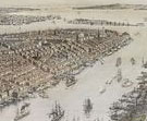 Julius
Bien is among the first generation of European-trained lithographers who helped
establish the American printmaking industry almost from scratch. Born and
trained in Germany, Bien settled in New York by 1849, where he opened a lithographic
firm that eventually employed over 200 people, and operated fifteen lithographic
steam presses. He is perhaps best known for his ambitious undertaking to lithographically
reproduce Robert Havell’s aquatints after John James Audubon’s
Birds of America. A cartographer as well as a printer, Bien produced
and printed thousands of maps of the growing country for use by state and
federal governments.
Julius
Bien is among the first generation of European-trained lithographers who helped
establish the American printmaking industry almost from scratch. Born and
trained in Germany, Bien settled in New York by 1849, where he opened a lithographic
firm that eventually employed over 200 people, and operated fifteen lithographic
steam presses. He is perhaps best known for his ambitious undertaking to lithographically
reproduce Robert Havell’s aquatints after John James Audubon’s
Birds of America. A cartographer as well as a printer, Bien produced
and printed thousands of maps of the growing country for use by state and
federal governments.
This view of New York was produced using the technique of chromolithography,
or multicolor lithography. Bien had very likely been exposed to early German
experiments in color printing while he was an art student, and was one of
the pioneers in the use of the technique in America. The equally prodigious
and talented John Bachmann, also probably a German native, was among the first
generation of artists to create bird’s-eye views of American cities,
which soared in popularity after the Civil War. Stokes declared that the interest
in such views was “a universal hobby – almost a mania.”
A game of baseball is shown in the left foreground of this view, at the Elysian
Fields, in Hoboken, New Jersey, where the first recorded baseball game was
played in 1846.
Note to the checklist. “Deák” refers
to the catalogue of American historical prints in the New York Public Library’s
collections: Deák, Gloria Gilda. Picturing America 1497-1899. Prints,
Maps, and Drawings bearing on the New World Discoveries and on the Development
of the Territory that is now the United States. 2 vols. Princeton: Princeton
University Press, 1988.