Part I: Founding Cities
Boston
Boston was founded by Puritans on the irregularly shaped Shawmut Peninsula,
a near island surrounded by the Charles River on the north and west, and a
sheltered harbor to the east and south. The peninsula’s first English
inhabitant was an Anglican minister who came in 1625. When the Puritans determined
to establish their “plantation” there in 1630, the peninsula was
marked with three distinctive elevations (known as Trimountain or Tremont).
In the 19th century, earth from these “mountains” was excavated
to fill in the Back Bay area, which greatly increased the surface area of
the city, expanding it from a peninsula to a solid piece of the coast. This
topographic transformation is evident in the map and views at right, from
the Pelham map showing the peninsula still tenuously tied to the mainland
by a thin strip of land, to two picturesque views drawn from the disappearing
hills, to the 1870 bird’s-eye view of the still-growing connection to
the coast.
Long an important seaport, Boston was the first major metropolis in the English
colonies, and the largest American city until Philadelphia and New York overtook
it in the course of the 18th and 19th centuries. A central player in the American
Revolution, the city has long been key in America’s historical and cultural
consciousness.
24
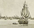
A Plan of Boston in New England with Its Environs
Francis Jukes (British, 1747–1812), after Henry Pelham (American, 1749–1806)
Etching and aquatint, published by Henry Pelham, 1777
Deák 148
 Soon
after the start of the American Revolution, the Loyalist-leaning Henry Pelham
began work on a map of Boston and its surrounding areas for use by British
intelligence. He was issued a pass, reproduced in the upper corner, giving
him “Permission to take a plan of the Towns of Boston and Charlestown
and of the Rebel works round these places in doing of which he is not to be
obstructed or impeded but has leave to pass and repass to and from.”
This map was shipped to London, where it was etched by Francis Jukes using
the newly introduced tonal method of aquatint. Fewer than twelve impressions
of this attractive and accurate map are known.
Soon
after the start of the American Revolution, the Loyalist-leaning Henry Pelham
began work on a map of Boston and its surrounding areas for use by British
intelligence. He was issued a pass, reproduced in the upper corner, giving
him “Permission to take a plan of the Towns of Boston and Charlestown
and of the Rebel works round these places in doing of which he is not to be
obstructed or impeded but has leave to pass and repass to and from.”
This map was shipped to London, where it was etched by Francis Jukes using
the newly introduced tonal method of aquatint. Fewer than twelve impressions
of this attractive and accurate map are known.
Son of the prominent mezzotint artist Peter Pelham, Henry was also half brother
to the great colonial painter John Singleton Copley. Soon after making this
map, he joined the Copleys and left for England, where he would remain until
the end of his life.
25
A View of Boston
Colored etching and aquatint, from The Atlantic Neptune, published
by Joseph F. W. Des Barres, 1779
Deák 136
 The
topographical views from The Atlantic Neptune, the collection of
charts and views of America prepared for the British Admiralty as the Revolutionary
War was getting under way, were intended to supplement the atlas’s marine
charts by giving seafarers visual clues for recognizing the approaches to
major harbors. The choice of charts and views in each individual set of The
Atlantic Neptune was made according to the needs of the ship for which
it was intended, although the final deluxe edition of 1784 included 258 plates.
The
topographical views from The Atlantic Neptune, the collection of
charts and views of America prepared for the British Admiralty as the Revolutionary
War was getting under way, were intended to supplement the atlas’s marine
charts by giving seafarers visual clues for recognizing the approaches to
major harbors. The choice of charts and views in each individual set of The
Atlantic Neptune was made according to the needs of the ship for which
it was intended, although the final deluxe edition of 1784 included 258 plates.
Des Barres involved himself critically in the printing and publishing of
the plates, much as he had seen to the accuracy of the surveys. This is apparent,
for example, in the use of the new technique of aquatint in views such as
this one of Boston harbor. In aquatint, the surface of the copper plate is
coated with a granular substance that acts as a resist, and when acid is applied,
the copper is bitten away from the exposed areas around the grains. The etched
areas will gather ink, producing wash-like areas of tone when printed.
26
View of Boston from Fort Hill
After William H. Whitmore (American, 19th century)
Ink and watercolor, ca. 1849
Deák 252
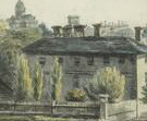 This
scene of Boston from Fort Hill is almost identical to a wood engraving published
in Justin Winsor’s four-volume Memorial History of Boston (1880–81).
The wood engraving is labeled as a view of the city in 1806; the watercolor
shows the same view minus foreground figures, but was updated to include the
Custom House, which was completed in 1849. According to Winsor, the source
of the wood engraving was a painting by William H. Whitmore [could it be the
prominent Boston historian of the same name (1836–1900)?], although
the relationship between the print and this watercolor remains unclear. The
Phelps Stokes Collection, although predominantly composed of prints, contains
a number of drawings, watercolors, and paintings.
This
scene of Boston from Fort Hill is almost identical to a wood engraving published
in Justin Winsor’s four-volume Memorial History of Boston (1880–81).
The wood engraving is labeled as a view of the city in 1806; the watercolor
shows the same view minus foreground figures, but was updated to include the
Custom House, which was completed in 1849. According to Winsor, the source
of the wood engraving was a painting by William H. Whitmore [could it be the
prominent Boston historian of the same name (1836–1900)?], although
the relationship between the print and this watercolor remains unclear. The
Phelps Stokes Collection, although predominantly composed of prints, contains
a number of drawings, watercolors, and paintings.
The fort on Fort Hill was built in 1637, and by the early 19th century, the
area had become a neighborhood of fine houses and gardens, as seen here. By
the mid-1860s, however, all the beautiful houses and landscaping had turned
into turf-less tenement squalor. Winsor reported that between 1866 and 1872,
as part of a grand city improvement plan, 547,628 cubic yards of earth were
removed from Fort Hill at a cost of $1,575,000. The earth from Fort Hill and
Boston’s other promontories became the landfill that created the Back
Bay area.
27
City of Boston
John Hill (American, b. England, 1770–1850), after Joshua Shaw (American,
b. England, 1776–1860)
Etching, with wash and watercolor, unpublished plate for Picturesque Views
of American Scenery, ca. 1820
Deák 318
 Joshua
Shaw and John Hill collaborated on a landmark of American landscape, the Picturesque
Views of American Scenery, a series of prints published in 1820–21.
This view was originally planned as part of the Picturesque Views,
but only half of the planned views were included in the original edition.
Joshua
Shaw and John Hill collaborated on a landmark of American landscape, the Picturesque
Views of American Scenery, a series of prints published in 1820–21.
This view was originally planned as part of the Picturesque Views,
but only half of the planned views were included in the original edition.
Shaw was already an accomplished painter in England before he came to America
in 1817. For this series he drew light-filled pastoral scenes, which launched
the Romantic movement in America. Hill, another Briton, settled in Philadelphia
in 1816, and was a key figure in American printmaking for bringing the technique
of aquatint from his homeland. For Picturesque Views, he first etched the
lines of the scene, and then built up tonal areas using aquatint. In this
print, one of five views that were made for the series but never published
as such, we are able to see the image in its early stage. As he was in the
habit of doing, Hill added wash and watercolor to indicate the areas where
aquatint would be applied.
28
Boston, from City Point near Sea Street
William James Bennett (American, b. England, 1787–1844), after his own
design
Etching and aquatint, published by John Levison, ca. 1853–56
Ford Collection
Deák 408
 Along
with John Hill, another English émigré, William James Bennett,
helped to bolster the development of printmaking in America. Trained at the
Royal Academy of Arts in London, Bennett arrived in New York in 1826. He continued
the practice begun by Hill of issuing finely crafted city views inspired by
the English topographical tradition. Bennett’s nineteen large folio
views of American cities favored harbor vistas that allowed him to express
a sense of atmosphere and light that became an integral part of the American
landscape tradition.
Along
with John Hill, another English émigré, William James Bennett,
helped to bolster the development of printmaking in America. Trained at the
Royal Academy of Arts in London, Bennett arrived in New York in 1826. He continued
the practice begun by Hill of issuing finely crafted city views inspired by
the English topographical tradition. Bennett’s nineteen large folio
views of American cities favored harbor vistas that allowed him to express
a sense of atmosphere and light that became an integral part of the American
landscape tradition.
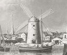
29
View of Boston
F. Fuchs (American, 19th century), after his own design
Chromolithograph, printed by New England Lithographic Company (Boston lithographic
firm, 19th century), published by John Weik, 1870
Deák 826
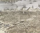 Bird’s-eye,
or aerial, views of cities originated in 16th-century Europe. They reemerged
in the mid-19th century in North America as a popular method of recording
the continent’s rapid urban development. Typically, the artist would
sketch a city’s layout from an elevated vantage point, and also make
detailed sketches of the facades of individual buildings. He would then combine
the information thus gathered to create a vista of the city as seen from an
imaginary aerial viewpoint.
Bird’s-eye,
or aerial, views of cities originated in 16th-century Europe. They reemerged
in the mid-19th century in North America as a popular method of recording
the continent’s rapid urban development. Typically, the artist would
sketch a city’s layout from an elevated vantage point, and also make
detailed sketches of the facades of individual buildings. He would then combine
the information thus gathered to create a vista of the city as seen from an
imaginary aerial viewpoint.
Boston’s important role as a seaport is perfectly captured in this
aerial view, which shows both the growing metropolis and the crowded harbor.
Chromolithography, in which the color is printed instead of laboriously applied
by hand to each impression, was widely used by companies such as the New England
Lithographic Company throughout the second half of the 19th century.
Note to the checklist. “Deák” refers
to the catalogue of American historical prints in the New York Public Library’s
collections: Deák, Gloria Gilda. Picturing America 1497-1899. Prints,
Maps, and Drawings bearing on the New World Discoveries and on the Development
of the Territory that is now the United States. 2 vols. Princeton: Princeton
University Press, 1988.
Next Section