Part I: Founding Cities
Philadelphia
In 1682, the year after King Charles II granted the Quaker William Penn control
of Pennsylvania, Penn instructed Thomas Holme to draw up a street plan for
“the virgin settlement of this province.” Penn’s utopian
vision of the city, to be located near earlier Swedish and Dutch settlements
between the Schuylkill and Delaware rivers, included large quadrants on which
each house would be surrounded by ample land. Although the plots became more
crowded than first envisioned, his ambition to create a religiously diverse
and wealthy city for the most part came true. Within seventy years –
from Holme’s original plan to Scull and Heap’s monumental profile
view – the city grew steadily and prospered economically and politically.
Penn spent little time in his province, but the story of his treaty with
the Indians under the great tree at Kensington (it was said that no blood
was shed between the Native Americans and the Quaker settlers) looms large
in city legend. The tree itself looms large in the foreground of the colored
aquatint after George Beck (number 22). During the American Revolution,
the Declaration of Independence was adopted in Philadelphia; the city hosted
the Continental Congress; and it served as the newly established country’s
second capital (after New York City, and while Washington, D.C., was being
built) from 1790 to 1800. The nation’s largest city by the late 18th
century, and the second-largest English-speaking city after London, it maintained
its role as financial capital until the mid-19th century.
18
An East Prospect of the City of Philadelphia
Gerard Vandergucht (British, 1696–1776), after George Heap (American,
active 1715–60), surveyed by Nicholas Scull (American, 1686?–1761?)
Etching, 1754
Deák 99
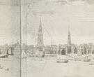 Encouraged
by the publication of large perspective views of two of America’s
greatest port cities, William Burgis’s engravings of New York in
1719 and Boston in 1725, Thomas Penn, son of Pennsylvania’s
founder, thought that Philadelphia was also worthy of such a grand representation.
Several artists failed to meet Penn’s expectations before artist
George Heap decided to independently issue his own view of the city from
across the
Delaware. Before he could make it to London to have the drawings engraved,
Heap fell ill and died. However, the project continued when Nicholas Scull,
who had published a map of the city with Heap in 1752, presented the drawings
to Penn. They were sent to England as planned, and etched and printed
from
four copperplates. A number of other versions based on this view appeared
in the ensuing decades (two of them are in this exhibition: number
19 and number 20).
Encouraged
by the publication of large perspective views of two of America’s
greatest port cities, William Burgis’s engravings of New York in
1719 and Boston in 1725, Thomas Penn, son of Pennsylvania’s
founder, thought that Philadelphia was also worthy of such a grand representation.
Several artists failed to meet Penn’s expectations before artist
George Heap decided to independently issue his own view of the city from
across the
Delaware. Before he could make it to London to have the drawings engraved,
Heap fell ill and died. However, the project continued when Nicholas Scull,
who had published a map of the city with Heap in 1752, presented the drawings
to Penn. They were sent to England as planned, and etched and printed
from
four copperplates. A number of other versions based on this view appeared
in the ensuing decades (two of them are in this exhibition: number
19 and number 20).
19
An East Perspective View of the City of Philadelphia, in the Province
of Pensylvania, in North America; Taken from the Jersey Shore
Possibly John Carwitham (British, active 1723–41), after George Heap
(American, active 1715–60), surveyed by Nicholas Scull (American, 1686?–1761?)
Colored etching, published by Carington Bowles, ca. 1778
Deák 101
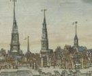 The
first panoramic view of Philadelphia, published in 1754 and known as the
Scull
and Heap view (see number 18), was reissued in various forms for the next
few decades. This highly colored version, for example, was published some
twenty
years later in London by Carington Bowles. Bowles, who operated an enormous
print establishment, had acquired the original Heap drawing and directed
an
engraver, possibly John Carwitham, to prepare a new, smaller version directly
from the original source.
The
first panoramic view of Philadelphia, published in 1754 and known as the
Scull
and Heap view (see number 18), was reissued in various forms for the next
few decades. This highly colored version, for example, was published some
twenty
years later in London by Carington Bowles. Bowles, who operated an enormous
print establishment, had acquired the original Heap drawing and directed
an
engraver, possibly John Carwitham, to prepare a new, smaller version directly
from the original source.
This view was one of 271 vues d’optique, or perspective views,
published by Bowles. These extremely popular views proliferated in 18th-century
Europe. They were intended to be viewed with a convex lens, generally in combination
with a mirror, sometimes in a box, which would exaggerate the strong diagonals
and bright colors of the scenes and make them appear almost three-dimensional.
20
An East Prospect of the City of Philadelphia
Thomas Jefferys (British, ca. 1710–1771), after Gerard Vandergucht (British,
1696–1776) and George Heap (American, active 1715–60), surveyed
by Nicholas Scull (American, 1686?–1761?)
Etching and engraving, published by Thomas Jefferys, 1756
Deák 100
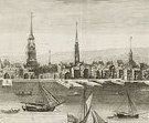 The
monumental 1754 panorama of Philadelphia (number
18) was not to everyone’s
liking. William Penn’s son, Thomas, objected to its oversized format
and the artist’s failure to clearly depict the city as a river port.
At Penn’s request, Gerard Vandergucht, who had engraved the earlier
print, prepared a reduced version, which pictured New Jersey in the
foreground
opposite Philadelphia, clearly showing the busy waterfront to be on a river.
The prominent London publisher Thomas Jefferys engraved and published
this
variant. Three new features were included: a map of the city, and inset views
of the Battery and the State House. This new version was less popular
than
the large prospect; 300 impressions, less than half the number of the Scull
and Heap edition, were issued.
The
monumental 1754 panorama of Philadelphia (number
18) was not to everyone’s
liking. William Penn’s son, Thomas, objected to its oversized format
and the artist’s failure to clearly depict the city as a river port.
At Penn’s request, Gerard Vandergucht, who had engraved the earlier
print, prepared a reduced version, which pictured New Jersey in the
foreground
opposite Philadelphia, clearly showing the busy waterfront to be on a river.
The prominent London publisher Thomas Jefferys engraved and published
this
variant. Three new features were included: a map of the city, and inset views
of the Battery and the State House. This new version was less popular
than
the large prospect; 300 impressions, less than half the number of the Scull
and Heap edition, were issued.
21
View of the City of Philadelphia
Gilbert Fox (American, b. England, 1776–ca. 1806), after John Joseph
Holland (American, b. England, ca. 1776–1820)
Colored etching, ca. 1796
Deák 210
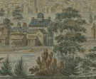 This
bucolic landscape, drawn from the western banks of the Schuylkill River with
Philadelphia looming in the distance, emphasizes the natural surroundings
from which the city rose so rapidly. Befitting its position as national capital,
Philadelphia began in 1790 to build a prominent New Theater, and the two artists
who produced this prospect of the city (both recent immigrants from London)
worked there. John Joseph Holland arrived in 1796 as a scenery painter at
the New Theater. Gilbert Fox, who etched Holland’s delicate bucolic
view, arrived in Philadelphia in 1795 and worked as a drawing master, actor,
and singer, premiering the country’s first national anthem, Hail
Columbia, at the New Theater in 1798.
This
bucolic landscape, drawn from the western banks of the Schuylkill River with
Philadelphia looming in the distance, emphasizes the natural surroundings
from which the city rose so rapidly. Befitting its position as national capital,
Philadelphia began in 1790 to build a prominent New Theater, and the two artists
who produced this prospect of the city (both recent immigrants from London)
worked there. John Joseph Holland arrived in 1796 as a scenery painter at
the New Theater. Gilbert Fox, who etched Holland’s delicate bucolic
view, arrived in Philadelphia in 1795 and worked as a drawing master, actor,
and singer, premiering the country’s first national anthem, Hail
Columbia, at the New Theater in 1798.
Stokes aimed to collect successive views of individual cities, claiming:
“Few have realized that the individuality of towns and cities is just
as pronounced and interesting as that of persons, and the study of the changes
which have taken place during their development throughout the centuries,
as illustrated by successive plans, views, and historical data, quite as revealing
and fascinating as the portraits and biographies of distinguished citizens.”
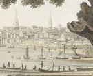
22
Philadelphia, from the Great Tree at Kensington, Under Which Penn Made
His Great Treaty with the Indians
T. Cartwright (British, active early 19th century), after George Beck (American,
b. England, 1748 or 1750–1812)
Colored etching and aquatint, published by Atkins & Nightingale, 1801
Deák 229
 In
1771, Benjamin West captured the public’s interest with his painting
William Penn’s Treaty with the Indians when he founded the Province
of Pennsylvania in North America, commissioned by Penn’s son, Thomas.
West portrayed this fateful gathering, which occurred soon after the founding
of Pennsylvania in 1682, as a peaceful event unfolding under the shade of
a large tree. Numerous prints after this painting soon followed and spread
throughout Europe.
In
1771, Benjamin West captured the public’s interest with his painting
William Penn’s Treaty with the Indians when he founded the Province
of Pennsylvania in North America, commissioned by Penn’s son, Thomas.
West portrayed this fateful gathering, which occurred soon after the founding
of Pennsylvania in 1682, as a peaceful event unfolding under the shade of
a large tree. Numerous prints after this painting soon followed and spread
throughout Europe.
George Beck’s view of Philadelphia is devoid of historical figures,
but uses West’s iconic setting as a symbol of the city’s founding.
Atkins & Nightingale, which issued this view in London, published several
prints by Cartwright after Beck, including views of Washington, D.C.,
and
Baltimore (both on view in the exhibition: number
14 and number
35).
23
Vue du Port de Philadelphie
Sigismond Himely (French, 1801–1872), after Louis Garneray (French,
1783–1857)
Colored aquatint, from Vue des côtes de France, published by
Hocquart and Bailly, Ward and Company, ca. 1843–44
Deák 432
 Philadelphia’s
location at the conjunction of the Delaware and Schuylkill rivers ensured
its position as one of the great port cities of the United States. Louis Garneray,
a French marine painter and engraver under Louis XVIII, chose to include this
city in his five-volume set of views of the ports of France, the last volume
of which centered on the greatest ports of the Western Hemisphere.
Philadelphia’s
location at the conjunction of the Delaware and Schuylkill rivers ensured
its position as one of the great port cities of the United States. Louis Garneray,
a French marine painter and engraver under Louis XVIII, chose to include this
city in his five-volume set of views of the ports of France, the last volume
of which centered on the greatest ports of the Western Hemisphere.
Garneray received his artistic training from his father, a painter who had
studied under Jacques-Louis David. He was, however, also a widely traveled
sailor, and thus had firsthand knowledge of the French ports in the series
of sixty-four views. It is less clear whether he visited any of the foreign
ports that are included in the final volume of the series, which may explain
the distortion in this view of Philadelphia.
Note to the checklist. “Deák” refers
to the catalogue of American historical prints in the New York Public Library’s
collections: Deák, Gloria Gilda. Picturing America 1497-1899. Prints,
Maps, and Drawings bearing on the New World Discoveries and on the Development
of the Territory that is now the United States. 2 vols. Princeton: Princeton
University Press, 1988.
Next Section