Part II: Settlement, Expansion, and the Business
of City Views
Mid-Western Cities
48
Die Balize an der Mündung des Missisippi
After Paul Wilhelm, Duke of Württemberg (German, 1797–1860)
Colored lithograph, 1828–35
Deák 334
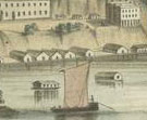
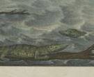 At
the mouth of the Mississippi River lies Belize, a pilot station situated along
the swampy riverbank. It was visited by the Duke of Württemberg, Paul
Wilhelm, who made several trips to the United States. He later published an
account of this journey, Erste Reise nach dem nordlichen Amerika in den
Jahren 1822 bis 1824, in which he described this town: “The few
wooden houses which make up the place stand on piles in the midst of the water
and slime, between high reeds; and one house can only be reached from another
along plank footpaths.”
At
the mouth of the Mississippi River lies Belize, a pilot station situated along
the swampy riverbank. It was visited by the Duke of Württemberg, Paul
Wilhelm, who made several trips to the United States. He later published an
account of this journey, Erste Reise nach dem nordlichen Amerika in den
Jahren 1822 bis 1824, in which he described this town: “The few
wooden houses which make up the place stand on piles in the midst of the water
and slime, between high reeds; and one house can only be reached from another
along plank footpaths.”
Among the Duke’s first impressions of the lower Mississippi, he noted
that “[n]ature seems to have destined this desolate region solely for
habitation of giant reptiles and countless mosquitoes.” Clearly impressed
by the alligators, he remarked that in the warm season “exceedingly
large numbers” of them inhabit the banks. “It seems a mystery
how these obviously voracious creatures are able to find prey enough to still
their hunger,” but nature provided them with a peculiarly long digestive
apparatus so they can go for long periods without food.
49/50
St. Louis; Memphis
Keokuck, Iowa; Prairie du Chien, Wisconsin
Arnz & Co. (German lithographic firm, 19th century), after Henry Lewis
(American, b. England, 1819–1904)
Tinted lithographs with hand-coloring, from Das illustrirte Mississippithal,
published by Arnz & Co., 1854–57
Deák 552 [.13, .22, .17, .4]
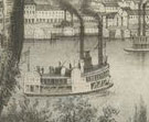
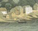
During the summers of 1846 to 1848, self-taught artist Henry Lewis traveled
the length of the Mississippi River making sketches. He pieced together these
scenes to create an 825-yard-long painting, Mammoth Panorama of the Mississippi.
It was exhibited as a moving panorama, shown in a special machine that slowly
unrolled the canvas while a speaker described the scenes. He toured the United
States and Europe with this spectacle before settling in Düsseldorf,
Germany.
In 1848, Lewis and Düsseldorf publisher Arnz decided to issue a series
of lithographs based on the sketches. The publication consists of seventy-eight
views with accompanying text by George B. Douglas about the places portrayed.
The introduction quotes letters from the U.S. President, a number of senators,
congressmen, and the governor of Wisconsin, bombastically praising the veracity
of Lewis’s panorama: “this artwork is so faithful and accurate,
that even though we have been familiar with the beauty of the place for many
years, we can only with difficulty be persuaded to believe that we do not
have the landscape itself before our eyes.”
51
Dubuque
Henry W. Petit (American, 19th century)
Tinted lithograph, published by W. J. Gilbert, ca. 1859
Deák 748
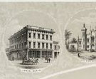 Julien
Dubuque was one of the first settlers of European descent in Iowa, in 1788.
Permanent white settlements were established only in the 1830s, however, after
the land was ceded by Sauk and Fox Indian tribes. The city of Dubuque was
chartered in 1841.
Julien
Dubuque was one of the first settlers of European descent in Iowa, in 1788.
Permanent white settlements were established only in the 1830s, however, after
the land was ceded by Sauk and Fox Indian tribes. The city of Dubuque was
chartered in 1841.
This lithograph, like many of the period, is distinguished by a series of
vignettes surrounding the main view. The artist and publisher described their
proposal beforehand in the local newspaper, citing their intention “to
surround the lithograph with views of the finest houses in Dubuque, in case
the owners are willing to pay the bare expenses of the lithographing”
and advised: “Those who wish to have views of their residencies or places
of business engraved upon the margin of the picture, should improve this opportunity
without delay, as the number is limited to ten or twelve.”
52
Cleveland, O.
Beck and Pauli (Milwaukee lithographic firm, 1876–89)
Tinted lithograph, ca. 1885
Deák 874
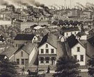 Ohio,
along with other states in the Midwest, became home to a growing German
population.
This view of Cleveland, a port city on Lake Erie, was commissioned by
the local German-language newspaper, the Cleveland Anzeiger, and
issued as a premium to subscribers.
Ohio,
along with other states in the Midwest, became home to a growing German
population.
This view of Cleveland, a port city on Lake Erie, was commissioned by
the local German-language newspaper, the Cleveland Anzeiger, and
issued as a premium to subscribers.
It was lithographed by the firm of Adam Beck and Clemens J. Pauli, which
operated out of Milwaukee. Their firm helped make the Midwest the center of
post–Civil War lithographic production. During their partnership they
printed half of all the bird’s-eye views issued in North America.
53
Cincinnati, Covington & Newport
Colored lithograph, ca. 1855
Deák 708
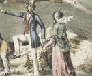 This
view of Cincinnati, Ohio, and Covington and Newport, Kentucky, is taken from
a slight elevation, a traditional format soon to be overtaken by aerial, or
bird’s-eye, views. The elegant figures in the foreground mimic the role
of the viewer gazing upon the cityscape. Although many of these prints are
beautiful, Stokes collected them also with a didactic purpose in mind, hoping
they would “not only give pleasure to the eye and educate the mind,
but stimulate civic pride and patriotism.”
This
view of Cincinnati, Ohio, and Covington and Newport, Kentucky, is taken from
a slight elevation, a traditional format soon to be overtaken by aerial, or
bird’s-eye, views. The elegant figures in the foreground mimic the role
of the viewer gazing upon the cityscape. Although many of these prints are
beautiful, Stokes collected them also with a didactic purpose in mind, hoping
they would “not only give pleasure to the eye and educate the mind,
but stimulate civic pride and patriotism.”
54
Saint Paul, Capital of Minnesota August 1853
Endicott & Co. (New York lithographic firm, 1852–86), after a photograph
by Joel E. Whitney (American, 1822–1886)
Tinted lithograph, published by Whitney & Le Duc, 1853
Deák 656
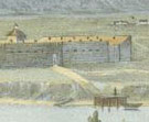
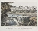 Although
explored by the French in the 17th and 18th centuries, Minnesota was not officially
opened to white settlers until 1837, and St. Paul was one of the first cities
founded in the territory. Local sites of interest, such as Fort Snelling (originally
Fort Anthony; built in 1819), and natural wonders, such as St. Anthony Falls
and Ha Ha Falls, appear as vignettes surrounding the main view of the banks
of the Mississippi.
Although
explored by the French in the 17th and 18th centuries, Minnesota was not officially
opened to white settlers until 1837, and St. Paul was one of the first cities
founded in the territory. Local sites of interest, such as Fort Snelling (originally
Fort Anthony; built in 1819), and natural wonders, such as St. Anthony Falls
and Ha Ha Falls, appear as vignettes surrounding the main view of the banks
of the Mississippi.
Maine-born photographer Joel Whitney moved to St. Paul in 1850 to open a
daguerreotype studio. He was one of the first to take photographs of this
city, many of which served as sources for lithographs and were published in
collaboration with local bookseller William G. Le Duc.
55
View of Chicago As Seen at the Top of St. Mary’s College
Augustus Köllner (American, b. Germany, 1813–1906), after August
Hermann Bosse (American, b. Germany, 1824)
Lithograph, printed by J. Henry Camp (Philadelphia lithographic firm, 1849–59),
ca. 1851
Deák 592
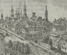 This
rare view of Chicago from the middle of the 19th century serves as an invaluable
record of the city’s appearance prior to the Great Fire of 1871. Sketched
by August Hermann Bosse, the view was then put on stone by Augustus Köllner.
Köllner, a German émigré, was primarily engaged from 1848
to 1851 in creating views of cities in Canada and America for the Paris–New
York firm Goupil, Vibert and Co. This lithograph, however, was one of the
few issued by the Philadelphian J. Henry Camp, with whom Köllner was
a partner until 1851.
This
rare view of Chicago from the middle of the 19th century serves as an invaluable
record of the city’s appearance prior to the Great Fire of 1871. Sketched
by August Hermann Bosse, the view was then put on stone by Augustus Köllner.
Köllner, a German émigré, was primarily engaged from 1848
to 1851 in creating views of cities in Canada and America for the Paris–New
York firm Goupil, Vibert and Co. This lithograph, however, was one of the
few issued by the Philadelphian J. Henry Camp, with whom Köllner was
a partner until 1851.
Stokes bought this print from a woman whose parents had resided in Chicago
between 1845 and 1846 and had acquired the lithograph as a fond reminder of
their days there. A curator from the Chicago Historical Society claimed to
know nothing of this print, but recommended it as highly desirable because
of the great dearth of images of the city from before the fire. She noted
that when it was built in 1844, St. Mary’s College was nearly the only
building that far north. Stokes paid more for this small view than he did
for many of his large bird’s-eye views.
56
Chicago in 1820
John Gemmell (American, active 1856–76), after Dominique C. Fabronius
(American, b. Belgium, 19th century)
Colored lithograph, published by Charles Sonne, ca. 1857
Deák 301
 Explorers
Jacques Marquette and Louis Jolliet were the first Europeans to come through
Chicago in the 17th century. Jean-Baptist-Point du Sable, a native of Saint-Domingue
(Haiti), created the first settlement there in 1779. In 1803, the United States
government established Fort Dearborn and within thirty years settlers began
flocking to the area. By the time of the Great Fire in 1871, which destroyed
nearly the entire city, 300,000 inhabitants resided there. This view was issued
as a premium with J. T. Palmatary’s View of Chicago, a swarming,
congested panorama that offers a marked contrast to this imagined view of
the city’s humble, austere beginnings.
Explorers
Jacques Marquette and Louis Jolliet were the first Europeans to come through
Chicago in the 17th century. Jean-Baptist-Point du Sable, a native of Saint-Domingue
(Haiti), created the first settlement there in 1779. In 1803, the United States
government established Fort Dearborn and within thirty years settlers began
flocking to the area. By the time of the Great Fire in 1871, which destroyed
nearly the entire city, 300,000 inhabitants resided there. This view was issued
as a premium with J. T. Palmatary’s View of Chicago, a swarming,
congested panorama that offers a marked contrast to this imagined view of
the city’s humble, austere beginnings.
57
Oklahoma City, Indian Territory
Albert E. Downs (American, 19th century), after Thaddeus Mortimer Fowler (American,
1842–1922)
Tinted lithograph, published by Thaddeus Mortimer Fowler, ca. 1890
Deák 878
 Oklahoma
was opened to settlers on April 22, 1889. Ten months later, Thaddeus Mortimer
Fowler recorded this view of a speedily populated yet orderly city, similar
to countless others cropping up throughout Middle and Western North America.
Fowler was the most prolific of all American view-makers, producing over 400
views from twenty-one states either as artist or publisher. Over half of these
were focused on the cities and towns of Pennsylvania, while the others were
sketched on his travels. His assistant, Albert E. Downs, transmitted the sketch
to the lithographic stone, and acted as co-publisher.
Oklahoma
was opened to settlers on April 22, 1889. Ten months later, Thaddeus Mortimer
Fowler recorded this view of a speedily populated yet orderly city, similar
to countless others cropping up throughout Middle and Western North America.
Fowler was the most prolific of all American view-makers, producing over 400
views from twenty-one states either as artist or publisher. Over half of these
were focused on the cities and towns of Pennsylvania, while the others were
sketched on his travels. His assistant, Albert E. Downs, transmitted the sketch
to the lithographic stone, and acted as co-publisher.
Note to the checklist. “Deák” refers
to the catalogue of American historical prints in the New York Public Library’s
collections: Deák, Gloria Gilda. Picturing America 1497-1899. Prints,
Maps, and Drawings bearing on the New World Discoveries and on the Development
of the Territory that is now the United States. 2 vols. Princeton: Princeton
University Press, 1988.
Next Section