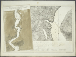
The Hudson River
 |
| J.F.W. Des Barres. Part of Hudsons
River … and (A Plan of Fort Montgomery & Fort
Clinton) …. London, 1779. NYPL, The Lionel
Pincus and Princess Firyal Map Division, Lawrence H.
Slaughter Collection. Digital
ID 434398 |
Traditionally considered to originate from the tiny Lake Tear
of the Clouds in the Adirondack Mountains, the Hudson River flows
over 300 miles from its source to the Atlantic. The river itself
is slight in comparison to the larger Hudson River watershed,
comprised of all the rivers, creeks, and wetlands that feed into
the river as it moves south. Approaching the harbor, the river
becomes part of a grand tidal estuary, with waters flowing “both
ways,” as the local Native American tribes described it.
The river ebbs and flows through the Upper and Lower Bays, moving
out into the Atlantic along the path of the historic Hudson Canyon
deep in the ocean floor. However, near Albany and Troy the shallows
of the river clearly demonstrated to Henry Hudson that he would
not find Asia via this path.
When Hudson left North America, he probably considered his efforts
to find a water route to Asia via the Hudson River a failure.
But the river supported fur trade and agricultural outposts, attracting
a new population to the river valley. To foment settlement, the
Dutch West India Company established a system of great manors,
called patroonships, along the Hudson and Connecticut river valleys.
Manor owners, or patroons, were required to bring immigrants to
develop and inhabit the land. The system eventually failed, but
agricultural and industrial development prospered, especially
in the 19th century.
The estuary, though threatened with industrial and population
pressures, continues to breathe life into harbor shores and communities.
Multiple environmental projects support the future of the river
and its harbor. Hudson River Valley wineries decorate the landscape,
continuing the heritage of the earliest winery here, established
by French Huguenots.