Exploration and Colonialism
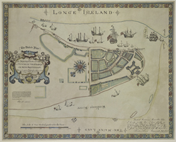 |
| [The Duke’s Plan] A Description of the Towne of Mannados or New Amsterdam …. New York, 1859; facsimile of 1664 original. NYPL, The Lionel Pincus and Princess Firyal Map Division. Digital ID 1650814 |
Henry Hudson was not the first European to sail along the northeast
coast of North America. Samuel de Champlain was exploring the
Saint Lawrence, and Lake Champlain, in 1609, the year Hudson traveled
up the North (now Hudson) River. However, it was Hudson’s
journals that first identified the value of the protected, ice-free
harbor, the potential fur trade, and possibilities for settlement
in the region.
The Dutch claimed the region between the English colonies of
New England and Virginia, bound by the Hudson River and the Delaware
(or South) River. Not a military, colonial, or religious establishment,
Nieuw Nederland, as the area was called, was a commercial venture,
under the control of a private stock company, the Dutch East India
Company.
Manhattan proved to be a convenient port for shipment of furs
and pelts back across the North Atlantic to Amsterdam. By 1625,
the trading post of the Dutch West India Company (which had supplanted
the Dutch East India Company) had grown into Nieuw Amsterdam,
a settlement located almost entirely below today’s Wall
Street, at the southern tip of the island. Farms, or bouweries,
north of Nieuw Amsterdam served as country homes, and also helped
feed the Dutch and Walloon settlers, who were soon joined by people
from across Europe, South America, and Africa, including slaves.
Some 23 languages were spoken in Nieuw Amsterdam, establishing
an international dynamic still present in the city today.
The English took control of Nieuw Nederland in 1664 and, once
here, mapped the newly named City of New York in detail. The British
bivouacked in the city throughout the American Revolution, and
their maps from this period include the only existing depiction
of the natural island in its entirety—from Spuyten Duyvil
to the Battery—without the 1811 grid overlaying and controlling
the land.
The English had never accepted the Dutch intrusion on “their” American
holdings—essentially and strategically split in two by Nieuw
Nederland. Once the Dutch were defeated, the historical record
was largely rewritten in favor of the English narrative. Thanks
to new research, the translation in recent decades of colonial
Dutch documents by the New Netherland Project in Albany, and the
celebration of the Henry Hudson quadricentennial, that lost Dutch
narrative has been revitalized.