The Greater Harbor
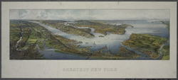 |
| H. Wellge. Greatest New York. New York: The New York Times Company, 1911. NYPL, The Lionel Pincus and Princess Firyal Map Division. Digital ID 1691404 |
The Upper and Lower Bays of New York Harbor, separated by the
Narrows, are part of a wider water-based geographic and economic
system that ranges from Long Island Sound, to the Connecticut
and Housatonic rivers, to the Hudson, the New Jersey wetlands,
and south down the Jersey shore to Delaware Bay. Coastal trade
from Boston to Florida, Atlantic ocean liners, New Jersey and
Long Island sloops, and pirate ships and privateers made their
way to and from this burgeoning New York market.
Long Island Sound offered a relatively protected route to New
England, reached through the notoriously dangerous Hell Gate.
The shallows and rocks there that sank thousands of ships were
finally conquered through the use of explosives, including gunpowder
and the newly developed dynamite, from 1866 to 1886.
The Jersey side of the harbor is revealed in views and maps that
detail the industrial and transportation history of its shorelines,
once even enhanced by a windmill, a bit of Dutch technology on
our shores.