Environmental Issues and the Future of the Harbor
 |
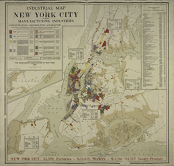
| Industrial Map of New York City Showing Manufacturing Industries. [New York]: Merchants’ Association of New York, 1922. NYPL, The Lionel Pincus and Princess Firyal Map Division. Digital ID 1691410. |
From Rye Beach to Sandy Hook, the shoreline offers a touch of
nature to balance our urban experience, and a place to enjoy fishing,
nature walks, swimming, and other playtime activities. With the
renewal of the Hudson River, even kayaking has become safe and
popular.
But the news is not all good. Oysters the size of dinner plates
disappeared from the harbor long ago. Whales are no longer seen
in the Hudson, and most fish claimed from its waters are not fit
to be eaten in quantity, if at all. Pollution, worn-out piers
and aging infrastructure, chemical and sewage spills, all have
taken their toll.
What is being done, and what is still to be done, to save and
improve this grand entrance to the nation? Newtown Creek has been
an environmental disaster since the mid-19th century, as articles,
reports, and maps well document. Today, an activist community
works toward its restoration and its future as a community asset.
In the 19th and early 20th centuries, Coney Island was a wonderland
of Ferris wheels, whiplashing rides, restaurants, hotels, and
more. Currently, this resort and respite from city life faces
pressure for new development.
A colorful example of the renewable spirit of the shoreline and
the city closes the exhibition: recycled beach glass is arranged
as a memento in mosaic form to the 400-year-old Dutch city below
the wall, Nieuw Amsterdam. Perhaps our participation in respecting
and saving our river and harbor environments will add to the optimism
we all hold about this great Port of New York and New Jersey.
We hope visitors take away from this exhibition both the wonder
of the port’s history and a commitment to its future.