Introduction
 |
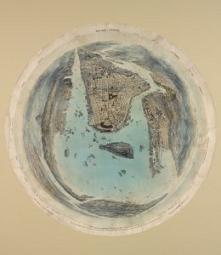
| John Bachmann. New York & Environs. New York, 1859. NYPL, The Miriam and Ira D. Wallach Division of Art, Prints and Photographs, Print Collection, Eno Collection. Digital ID ps_prn_647 |
September 2009 marks 400 years since Henry Hudson sailed into
New York Harbor and up the river that now bears his name, almost
to what is now Albany, performing
detailed reconnaissance of today’s Hudson Valley region. Other explorers
passed by the outwardly hidden harbor; they failed to fully recognize the commercial,
nautical, strategic, or colonial value of the region. Once these explorers returned
to Europe, much of the information they had gathered was presented to mapmakers,
whose works were engraved on copper and printed on handmade paper. These maps
were then distributed to individuals and coffee-houses (the news outlets of the
day), and pored over by dreamers, investors, and potential settlers in the “new
land.”
The European powers had been seeking a quick route to Asia
and its treasures for centuries, but it was an unexpected treasure
that they found on the Atlantic coast—the commercial
port of Nieuw Amsterdam. The geography of the area featured
a protected year-round harbor in a temperate climate, with
access to extraordinary natural resources. This port subsequently
evolved into today’s most important international city,
New York. Mapping New York’s Shoreline celebrates the
Dutch accomplishments in the New York City region, especially
along the waterways forming its urban watershed, and the Dutch
heritage that remains today in place names decorating the metropolitan
region (and in place names honoring Henry Hudson himself),
and in our tremendous commercial, political, and social history.
Drawing on The New York Public Library’s collection
of Dutch, English, French, and American mapping of the Atlantic
coastal regions, this exhibition exemplifies the best early
and growing understanding of the “unknown” shores
along our neighboring rivers, bays, sounds, and harbors. From
maps reflecting Verrazzano’s brief visit, to decorative
Dutch charting of the Atlantic and Nieuw Nederland (New Netherland)
region, the works illustrate the expanding awareness of trading
opportunities. A unit on the Rutgers Farm, an early Dutch brewery
and farm situated in the present-day Lower East Side, illustrates
the evolution of the metropolitan area from rural landscape
to urban region in the course of the 18th and 19th centuries.
The exhibition extends to a 21st-century perspective, including
maps and texts highlighting environmental concerns for this
harbor and for the river that continuously enriches it. From
paper maps to vapor maps, created with state-of-the-art computer
technology, this exhibition celebrates New York Harbor on the
occasion of the Henry Hudson quadricentennial.
The four circular maps that open the exhibition reflect the
world centered around the harbor. Life along the shorelines
that feed into the great port has changed greatly over the
past 400 years, yet the water-defined environment retains much
of its centuries-old patterns. The river, the estuary, the
tide, and the harbor persist and thrive.
Alice C. Hudson, retired Chief
The Lionel Pincus and Princess Firyal Map Division
Support for this exhibition has been provided by the Estate
of Ronald Eaton
Moehle, City Planner and NYPL Mercator Society member, and
by a gift in memory of Larry Slaughter.
Support for The New York Public Library’s Exhibitions
Program has been provided by Celeste Bartos, Mahnaz Ispahani and Adam Bartos,
Jonathan Altman, and Sue and Edgar Wachenheim III.
© The New York Public Library, Astor, Lenox and Tilden Foundations, 2009. All rights reserved.