From The Netherlands to Nieuw Nederland
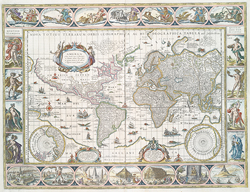 |
| Willem Blaeu. Nova totius
terrarum orbis geographica ac hydrographica tabula [New
Geographical and Hydrographical Map of All the Lands
of the World]. Amsterdam, ca. 1630. NYPL, The Lionel
Pincus and Princess Firyal Map Division, Lawrence
H. Slaughter Collection. Digital
ID 465003. |
Little is known of Henry Hudson (d. 1611) before he suddenly
appears on the world stage as a sea captain and explorer. He likely
gained experience as a third- or fourth-generation Hudson family
member working in the London-based Muscovy Company, which sought
to open up trade between England and Russia. Although he was English,
Hudson sailed for the Dutch. This was not unusual—the Italians
Giovanni Caboto (John Cabot) and Giovanni da Verrazzano sailed
for England and France, respectively.
Hudson was originally hired by the Dutch East India Company to
sail north over Russia to find a “northeast passage” to
Asia. But on his third recorded voyage, aboard the Half
Moon,
cold and ice forced him to detour to the western Atlantic. He
hoped that this route would prove to be the elusive “northwest
passage” to China that all Western European nations desperately
sought, as they competed for trade with Asia. Instead, he found
the harbor of New York and the North (now Hudson) River. Hudson’s
explorations laid the foundation for a robust fur trade that further
enriched the Dutch nation, already wealthy from its trade in East
Indies goods and in control of much of the world economy.
World maps from the 17th and 18th centuries portray the known
and named world as Hudson and Dutch explorers and traders would
have known it. Note the density of place names along the shorelines
(the first and most well-known areas explored, and thus mapped)
of the various continents, and the few place names in mid-continent.
The latter areas are often covered by a cartouche (a title label
on a map) or some decorative motif, to mask the ignorance of what
exactly is located in these interiors.
As the Dutch and English explored and settled the Middle Atlantic
coast, more detailed maps appeared, including the Hendricks and
Southack portrayals. These lead us to the more comprehensive maps
of settled life in Nieuw Amsterdam.