Exploring the West
"Any observations of your own… in the Western country, will come accceptably to me.… Descriptions of animals, vegetables, minerals, or other curious things, notes as to the Indians, information of the country between the Missisipi [sic] and waters of the South sea &c. &c. will strike your mind as worthy being communicated." — Thomas Jefferson, writing to George Rogers Clark, November 26, 1782
The European or American approach to understanding the West
required detailed mapping, but early attempts to map the West were
fragmentary and scattered in nature. The vast area west of
the Mississippi was mapped only in stages, over many decades.
Easily transported from one place to another, maps imposed
"order" and enhanced the understanding of the region by
outsiders, from East Coast settlers to those in Congress and
assorted halls of power.
Geographical understanding of the West changed after gold was
discovered in California in 1848, when massive exploratory
expeditions were funded and organized by the federal government to
find railroad routes to the Pacific coast. These expeditions resulted in
maps that filled in pieces of the Western mosaic for Easterners.
Nothing equivalent comes to mind, unless we think of the federal
money and attention expended on the space race.
Scientific and military expeditions to study and map the West
particularly suited the sensibilities of the Victorian era, which
was a time of intense interest in exploration, geography, and
knowledge of the earth and all its creatures, plants, animals,
rocks, rivers, and deserts. Everything was examined, cataloged,
described, and illustrated.
The need to create detailed mapping of wide-open spaces may
wrongly imply emptiness and non-inhabitance before the
cartographer appeared on the scene. Yet in the West, Native
Americans, because of their relation to the land and sense of
space, did not require paper maps and technical surveys. Their
knowledge of the land was valued, sought after, and recorded on
maps, usually to their own later detriment. Incorporated into maps
based on data from official surveys, Native American information
complements and enhances the data on military and commercial maps
throughout this online exhibit.
 1
1
|
|
|
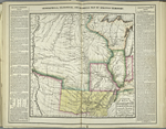
Stephen H. Long Geographical, Statistical and Historical map of Arkansas Territory, 1822 NYPL, Map Division |
|
 2
2
|
|
|
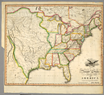
John Melish United States of America compiled from latest and best authorities…, 1818 NYPL, Map Division |
|
 3
3
|
|
|
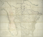
Aaron Arrowsmith A Map Exhibiting All the New Discoveries in the Interior Parts of North America, 1795, updated to 1839 NYPL, Map Division |
|
|
|
|
|