This website is part of The New York Public Library's Online Exhibition Archive. For current classes, programs, and exhibitions, please visit nypl.org.
  < Previous section | Next section >
< Exploring Intro | Image: 1 2 3 >


Exploring the West

 
  Map of United States of America, 1818   John Melish
United States of America compiled from latest and best authorities…
Philadelphia, 1818
NYPL, Humanities and Social Sciences Library, Map Division
 
 
Pointer to graphic links to enlargement Click here or on image to enlarge  


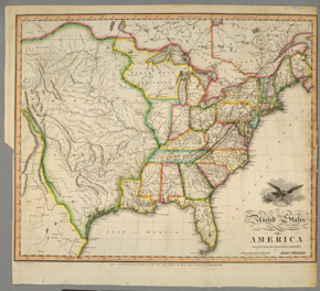
The eagle and shield form a patriotic coat of arms over the title piece on this map. The State of Louisiana has been carved out of the old Louisiana Purchase, now called the Missouri Territory. The detailed river information reflects Lewis and Clark data which this commercial publisher has copied. "Highest Peak," is later to be known as Long's Peak, after explorer Stephen H. Long. Melish does not incorporate the "Boiling Springs" information on Yellowstone, as he, like most East Coast publishers, probably found it unbelievable.

Reproductions and Permissions

 
Privacy Policy | Rules and Regulations | Using the Internet | Website Terms and Conditions | © The New York Public Library