|
|
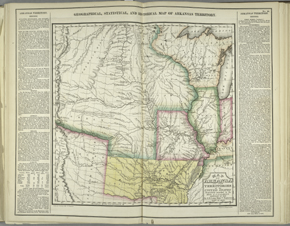
The text that accompanies this 1822 map, from the first U.S. atlas
to provide separate maps of the various states and territories,
openly discusses the removal of Cherokees from their residence
east of the Mississippi and their resettlement in Arkansas
Territory, later Oklahoma. The publishers, Carey & Lea,
acknowledge "the politeness of Major [Stephen H.] Long, of the
Corps of Engineers, for the use of his Manuscript map of the
Western Territories, constructed from surveys made in his last
expedition to that country, under the direction of the department
of War." Major Long is best known for designating the Great
Plains region as the "Great Desert" on this map; some
scholars think this designation alone had a very powerful negative
effect on the settlement of this area.
Long's map was first published, not as a government
document, but in a profit-making commercial atlas with wide
popular distribution. The map emphasized political boundaries with
strong color, but careful examination reveals geological formation
boundaries, Spanish and Indian trails, explorers' routes, and
tribal boundaries imposed by the federal government.
The text openly discusses the removal
of Cherokees from east of the Mississippi and
their settlement in Arkansas Territory, later Oklahoma. A
Christian mission was established to "teach them
the arts of civilized life, and to instruct them in
Christianity." As the Cherokees had previously adopted a
"civilized life," with permanent villages, agricultural
economy, a written language, etc., one wonders what else they
evidently needed to learn.
Reproductions and Permissions
|
|

