Settling the West
"…turn your face to the Great West, and there build up a home and fortune." — Horace Greeley, quoted in James Parton, The Life of Horace Greeley, Editor of the New York Tribune (1855)
By fits and starts, beginning with the colonial settlers, the
Eastern population moved west. Despite George III's Proclamation
of 1763, which prohibited settlement west of the Alleghenies
[Appalachians], the inevitable push away from the East Coast could
not be stopped. No longer a paradisiacal land of fable, dream, and
imagination, the West was to become for the settlers a workaday
world of farms, cities, transportation grids, and national parks,
with people drawn there by its very promise of a new life.
However, the land in the West was not uninhabited. Native Americans had
occupied the continent for centuries. The earliest maps in this
exhibition provide a valuable record of groups no longer extant.
Maps also reveal the patterns of displacement that Native
Americans faced as they settled around U.S. military forts and
were rounded up into "reservations." The reorganization
of their monumental, unbounded open space into small, gridded,
controlled places defines the "reservation" program of
the federal government.
Very evident on the maps in this section is the "township and
line survey," established by the Continental Congress in
Philadelphia with the Ordinance of 1785, which divided lands into
new territories and future states beyond the Appalachians. Very
rational and orderly, the grid marches over mountains and down
river valleys, maintaining its viselike grasp on the land through
the ever-present grid of 36-square-mile "towns." While
the overall township grid clearly defined property lines, it also,
and even more importantly, gave the federal government control
over the land from a distance.
 1
1
|
|
|
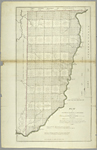
Mathew Carey The Seven Ranges of Townships, 1814 NYPL, Map Division |
|
 2
2
|
|
|
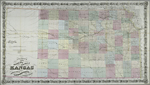
Colton's New Sectional Map of the State of Kansas, 1868 NYPL, Map Division |
|
![Birds [sic] Eye View of the City of San Francisco](assets/thumb/HW108.JPG) 3
3
|
|
|
Snow & Roos Birds [sic] Eye View of the City of San Francisco, 1868 NYPL, Map Division |
|
|
|
|
|