This website is part of The New York Public Library's Online Exhibition Archive. For current classes, programs, and exhibitions, please visit nypl.org.
  < Previous section | Next section >
< Settling Intro | Image: 1 2 3 >


Settling the West

 
  Map of the State of Kansas, 1868   
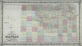
Colton's New Sectional Map of the State of Kansas
New York: G.W. and C.B. Colton & Co., 1868
NYPL, Humanities and Social Sciences Library, Map Division
 
 
Pointer to graphic links to enlargement Click here or on image to enlarge  


Published only seven years after Kansas was admitted to the Union, this map exemplifies the township and range survey. The western third of the state has not been surveyed beyond the railroad head at Coyota. Notice the detail of the dendritic river patterns in the surveyed counties and the lack of detail farther west, where rivers are just vague suggestive lines. While two-thirds of the state is carefully surveyed, it is not necessarily settled, or even developed. The previous owner of this map had pencil-marked two sections of land in Atchison County, Kansas, in the northeastern corner of the state, perhaps for purchase.

G. Woolworth Colton is careful to state that his map has been "compiled from the United States Survey & other authentic sources," as he seeks to lend authority to his work. At the lower left-hand corner Colton has drawn the map outside the lines as he seeks accuracy over beauty, ending up in the decorative shell and vine-scrolled border. He uses seven fonts in the title, perhaps to be splashy and show off his abilities as a graphic designer, or to lend authority via the importance of the very formal typefaces. The bright colors on this map are very typical of Colton maps, and were applied by the use of a stencil technique for speed of production.

G. Woolworth Colton was the son of Joseph Hutchins Colton, the founder of the great Colton mapping firm, based in the lower Manhattan business district during the mid to late 19th century. This family firm published maps, atlases, guidebooks, and geography texts for almost 70 years. The Colton firm has a very small advertisement for its mapping services at the lower left: "Maps of every description to accompany Reports, Prospectuses, etc. Drawn, Engraved, Printed & Colored at Colton's Geographical Establishment, No. 172 William St., New York."

Reproductions and Permissions

 
Privacy Policy | Rules and Regulations | Using the Internet | Website Terms and Conditions | © The New York Public Library