Settling the West
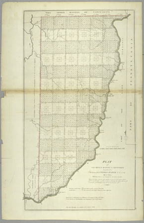
"The Seven Ranges of Townships"
From: his General Atlas
Philadelphia, 1814
NYPL, Humanities and Social Sciences Library, Map Division

|
Click here or on image to enlarge |
|
< Settling Intro | Image: 1 2 3 > |
|
|
|||||||
|
Settling the West
|
|||||||
|
|
Mathew Carey "The Seven Ranges of Townships" From: his General Atlas Philadelphia, 1814 NYPL, Humanities and Social Sciences Library, Map Division |
||||||
|
|||||||
|
This 1814 map shows "the seven ranges of townships" in
southeastern Ohio, west of the Ohio River, the first area to be
surveyed following the 1785 congressional ordinance; all new
territories and states north and west of the Ohio were to be
surveyed in this fashion, regardless of topography. The square,
gridded Western lands we know today are the result of this
original survey plan. The river sketches along the borders of the
townships suggest that the surveyors made note only of those that
crossed their path, and did not actually observe rivers within the
townships. Individual sections of towns were not surveyed until
land was settled or sold.
|