|
|
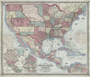
Much as reins control a horse, maps are about control of the land.
Exuberant graphics, strong color, bold boundary lines, and text
proclaiming ownership all work together to gather in and brand the
entire country, the control of which, from ocean to ocean, was
seen as America's "manifest destiny."
While many of the government maps are very plain, large,
black-and-white technical productions, this Johnson & Browning
commercial wall map is alive with state and territorial boundaries,
notes, illustrations, and color,
used aggressively as a symbol of possession.
Seemingly no part of the country is left untouched, or in a
"frontier" condition.
The vivid coloring
reflects a particular point of view, an East Coast
commercial perspective rather than a Western documentary sensibility. Many of
the details on this map -- explorers' trails, transportation
routes, and settlement patterns -- recur on other maps in this
online exhibition.
This mid-19th-century map displays settlement patterns
still seen today: densely populated Eastern states contrast with
the more sparsely populated West. But the nation is on the brink
of war, and everywhere the map seems in motion. Wagon roads follow
paths of least resistance, the river valleys, as do the railroad
lines, both existing and planned. Sailing ships dot the oceans,
symbolizing trade and worldwide access to goods and markets. The
stagecoach mail route to San Francisco from the railheads near St.
Louis and Memphis is boldly marked, suggesting that this map was
designed for use in places of business or local post offices. The
Butterfield Stage carried the mail across the southwest until the
railroads were completed and took over express services.
At the lower left, the international importance and weight of the
United States is pointedly symbolized by its central placement on
the world map, which emphasizes shipping routes to and from the
Americas.
Reproductions and Permissions
|
|