Heading West: Mapping the Territory
According to an old adage, a place is not discovered until it is
mapped. Through impressions of the West in maps from 1540 to 1900,
this online exhibition presents an overview of the process, which
continues today.
Many minds and hands were involved in the mapping process: the
delineator in the map studio, engraver on copper or stone,
lithographer, paper maker, printer/publisher, colorist, binder,
book/mapseller, purchaser or government client, and, of course,
the explorer in the field, who often drew on Native American
knowledge of the land. New information from explorers or surveyors
resulted in revisions or even entirely new maps. Often latching
onto the mantle of government authority, commercial mapmakers
trumpeted the authoritative federal sources for their particular
maps.
Despite the myth that it was independent heroic spirits --
pioneers, cowboys, gunslingers, and marshals -- who conquered the
West, it was more likely government powerbrokers who inspired,
paid for, controlled, and benefited most from the capture of the
West on paper. From Lewis and Clark in the first part of the
19th century to G. K. Warren in the latter,
mapping expeditions were federally run topographical surveys or
military operations. The copyright-free government maps that
resulted from these expeditions facilitated the rise of commercial
mapmaking, as they became fodder for mapmakers in Philadelphia,
Chicago, New York, and Washington, D.C. At the same time, private
commercial interests became involved in surveying and mapping the
area, first because of the fur-trading activities based in St.
Louis and the upper northwest and, later, as railroad investors
raced to conquer the West.
Heading West: Mapping the Territory
reveals the evolution on paper from an imagined West to a mapped
West, seemingly defined yet still a fiction of sorts. Early on,
imaginative maps implied an easy
route across America to Asia -- a land of jewels and spices, to
which access by traditional routes was blocked. Once aware of the
immensity of the American continent, those in power sought to
explore and to map it. The
surveying and settlement of the
territory west of the Appalachians aggressively
changed the face of the land. The discovery and
mining
of gold, and the continuing desire for access
to Asian markets, inspired exploration and improved means of
transportation across the
continent. The maps in Heading West have been organized
into five thematic categories, but individual maps often provide
information relating to more than one, or even all, of them.
Grids of property lines, township surveys, railroad lines, wagon
trails, state and county boundaries -- all criss-crossed the land,
in reality and on paper. The trails west are many; the maps
show the way.
The materials in Heading West are drawn primarily from the
Map Division, which includes the Lawrence H. Slaughter Collection
and the Levine Bequest.
Alice C. Hudson
Chief, Map Division, Humanities and Social Sciences Library
Support for the Exhibitions Program at The New York Public Library's Humanities and Social Sciences Library has been provided by Pinewood Foundation and by Sue and Edgar Wachenheim III.
The New York Public Library for the Performing Arts gratefully acknowledges the leadership support of Dorothy and Lewis B. Cullman. Additional support for programs and exhibitions has been provided by Judy R. and Alfred A. Rosenberg and the Miriam and Harold Steinberg Foundation.
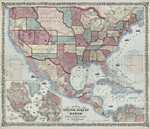
Johnson & Browning
Map of the United States and Mexico, 1859
NYPL, Map Division
Many of the details on this map -- explorers' trails, transportation routes, and settlement patterns -- recur on other maps in this online exhibition.
Click here or on map image above to enlarge
westward expansion
American West