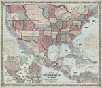
Traveling the West
"And the Iron Horse, the earth-shaker, the fire-breather, which tramples down the hills, which outruns the laggard winds, which leaps over the rivers, which grinds the rocks to powder and breaks down the gates of the mountain, he too shall build an empire and an epic." — "Statistics and Speculations Concerning the Pacific Railroad," Putnam's Magazine, September 1853
The transport of European and then American people and goods
across the North American continent spread incrementally from the
East Coast, over the Appalachians and via land and water. The
rivers, from the Saint Lawrence to the Potomac and Ohio, were
critical passageways, and the watershed of the Mississippi, while
thought of as a vertical pathway, was truly an East-West water
highway, with valleys easing the way west. Native American
cross-country paths, used for centuries before European contact,
formed the basis for many later post roads, highways, and
railroads.
The Oregon country became a target for settlers early on. Wagon
roads had to be built to carry them west, and the federal
government sent Army troops to survey and build these roads.
Long-established trade routes, such as the Santa Fe trail, were
surveyed and improved. These expeditions, along with those of
later topographic and military engineers who surveyed lands for
potential railroad routes, continued to fill in the map of the West.
The discovery of gold in California added to the interest in
strong East-West communication, and the major railroad lines
crossed the country as the Civil War erupted. In his capacity as
U.S. Secretary of War, Jefferson Davis (later to become President
of the Confederacy) was in charge of the railroad surveys. Many of
the topographical engineers took their military and mapping skills
into the Civil War, among them John Charles Frémont,
William H. Emory, G. K. Warren, and Amiel Whipple.
The railroads rapidly developed, not only as a means to get from
point A to point B, but also as tourist transit to Yosemite Valley
and Yellowstone National Park. The West became a destination.
 1
1
|
|
|
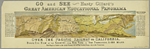
Hardy Gillard Over the Pacific Railway to California, [1880] NYPL, Map Division |
|
 2
2
|
|
|
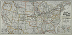
George F. Cram New and Correct Map of the Great Rock Island Route, 1883 NYPL, Map Division |
|
 3
3
|
|
|
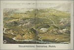
Henry Wellge Yellowstone National Park, 1904 NYPL, Map Division |
|
|
|
|
|