Imagining the West
"Few people even know the true definition of the term 'West'; and where is its location? -- phantomlike it flies before us as we travel…" — George Catlin, Letters and Notes on the Manners, Customs, and Condition of the North American Indians (1859)
America was in the way. It was not made up of islands, as the
16th-century cosmographer Sebastian Münster would
have had us believe, nor was there a clear sailing passageway to
Asia. America, with its mysterious Western shore, was a continent
to be reckoned with. Still, Europeans of the 16th and
17th centuries wanted easy access to Asia. Might there
be a passage across the pesky new continent? If such a passage was
drawn on the maps, perhaps it could eventually be found. The
fantasy of an easy passage from Europe to Asia, by going west and
bypassing Dutch-, Spanish-, and Portuguese-controlled areas and
the Ottoman East, lasted into the 19th century,
becoming somewhat of a reality as the railroads crossed the
American continent.
Maps in this section display both an imaginary West that never
was, and, bit by bit, an increasingly sure awareness of the
actual width and solidity of the continent, portions of which were under
the control at different times, and sometimes even at the same
time, of France, England, Spain, Russia, and the Netherlands. As
power shifted across the continent of Europe, tremors were felt in
North America: Napoleon acquired the Louisiana Territory from
Spain, and the French threatened to chokehold the United States
from New Orleans to Hudson's Bay. The Louisiana Purchase by Thomas
Jefferson ended that threat in 1803, and expanded U.S. options
westward into unknown lands.
 1
1
|
|
|
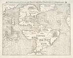
[Sebastian Münster] Tabula Nouarum Insularum… Occidentales & Indianas Uocant, [1540] NYPL, Map Division |
|
![America, [1626]](assets/thumb/HW005.JPG) 2
2
|
|
|
John Speed America, [1626] NYPL, Map Division |
|
 3
3
|
|
|
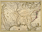
Guillaume de L'Isle Carte de la Louisiane et du Cours du Mississipi, [1718-1730] NYPL, Map Division |
|
|
|
|
|