|
|
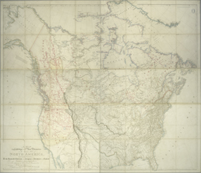
This very large wall map from the premier English cartographer
Aaron Arrowsmith displays what was meant to be the latest
information from North America. Fur traders in the Hudson Bay
Company employ were required to send reports and geographic data
back to London for the Arrowsmith firm to incorporate into their
maps. The importance of new information is shown in the series of
printed "additions" or updates: 1795, 1811, 1818, 1819,
1820, 1824, 1833, 1839. The red ink markings are post 1839, and
are not among the "additions" referred to on the printed
portion of the map.
This particular map displays the red ink of its cartographic
editor or reviser. The lettering is professionally applied, and in
some areas a faint pencilled grid can be seen to guide the
mapmaker in his work. In the area of the Great Basin, covering
Utah and Nevada, a sizable portion of the original map has been
removed, and replaced with an inset of paper, on which other
information has been supplied. However, it seems not to be new
information, but copied from earlier sources.
Canada looms over the United States, which is limited to the area
east of the Mississippi on this map. The Missouri Territory
remains curiously unnamed, but the original base map on which this
map is based is dated 1795. The hand colored border reflects a
Mexican border east to the Sabine River. The Missouri River is
shaded with hachures up to the Yellowstone River, making it
stand out on the plate, as it is the only river so treated. Roads
are designated by single lines.
Reproductions and Permissions
|
|